In the middle of Lower Silesia a single mountain rises out of the plain, 718 metres high, wooded, with enigmatic stone figures on its slopes. The Poles call it Ślęża, the Germans Zobten. Around it lived, in the early Middle Ages, a Slavic group that the sources call Sleenzane or Silensi, in German scholarship Slensanen, and whose name may have given the whole land its name. May. This article sorts what written sources say, what excavations show, what later tradition tells and what modern scholars make of it. And it explains why the Slensanen need not have anything to do with the East Germanic Silingi, although the two are so often named in one breath.
The Slensanen left nothing of their own. No inscription, no self-designation, no list of rulers. What we know comes from outsiders: an author in south-west Germany who in the 9th century lists peoples north of the Danube, a Saxon bishop who writes about the eastern edge of the empire a century and a half later, and a Prague chronicler who in the late 11th century reproduces a boundary description. Add a mountain on which people left traces over millennia.
With such material it is tempting to shape a whole people out of a few sentences. We keep to one rule: first the written source, then the find, then the tradition, then the interpretation. Where these four blur, we say so.
The oldest mention stands in a short Latin text known as the Bavarian Geographer (Descriptio civitatum et regionum ad septentrionalem plagam Danubii). It lists peoples north of the Danube and gives each the number of its civitates, literally strongholds or fortified districts. In the second list the entry reads, in the usual reading of the editions:
Sleenzane civitates XV. The Sleenzane (have) fifteen strongholds.Bavarian Geographer (Descriptio civitatum et regionum ad septentrionalem plagam Danubii), second list; translation our own, spelling after the usual edition (manuscript Munich, Clm 560)
That is all. The text does not say where the Sleenzane lived, who led them or what a civitas was: a ring rampart, a settlement with a palisade or merely an administrative district. That the Sleenzane are the people around the Zobten is an identification made by scholars, resting on the similarity of the names and on Thietmar's later note (see below). It is well founded, but it remains an identification.
The origin of the text is also open. Bernhard Bischoff thought of a monk on the Reichenau in the 830s to 850s, Aleksandr Nazarenko of the 870s; Henryk Łowmiański showed that the list consists of two parts that may have arisen at different times. The Geographer is called Bavarian after its place of storage, the Bavarian State Library. Where the author sat we do not know for certain. The same list contains the Opolini with twenty strongholds and the Golensizi with five; you can read more about the Opolans in a separate article.
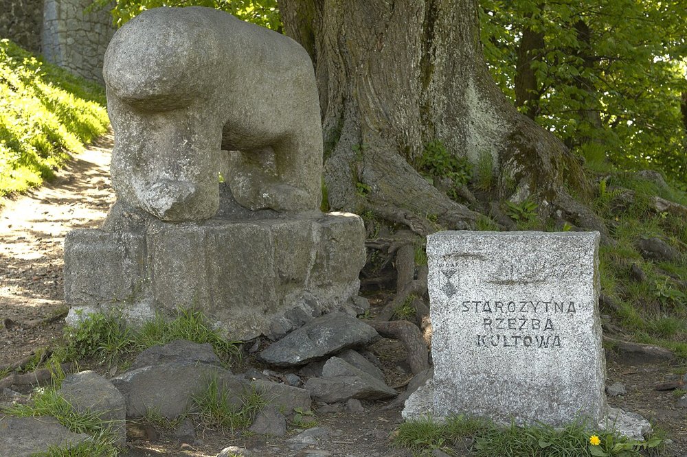
The mountain lies a good thirty kilometres south-west of Wrocław. It consists of dark Zobten gabbro, a plutonic rock resembling granite, and stands like a sentinel above the flat foreland. That such a mountain occupied people is no surprise. Near the summit and on the slopes stand stone figures known as the Fish Woman, the Bear and the Boar, plus other shapes that are hard to make out.
Here we separate for the first time. What is established is that these sculptures exist and are worked from the mountain's own rock. Widely assumed but not proven is that the mountain was already a cult place in the Bronze and early Iron Age; scholars link it with bearers of the Lusatian culture. The dating of the figures themselves is open. Proposals range from prehistoric, in part even Celtic, to the early Middle Ages. Whoever reads in a guidebook that the figures are Celtic reads an interpretation, not a result. The same applies to the older thesis that the Zobten was the sacred grove of the Alcis mentioned by Tacitus in the Germania: it has been considered, not proven.
In the early 12th century Piotr Włostowic founded an Augustinian convent on the mountain, moved to Wrocław in 1153. This too belongs to the story of a place that Christians later occupied deliberately. Whether they took up an older pagan veneration is plausible but cannot be read from this note.
The second written source comes from Bishop Thietmar of Merseburg, who wrote his chronicle in the 1010s. According to the account that scholars such as Matthias Hardt give, Thietmar names a pagus Silensi, a district that took its name from a very high and extensive mountain, the mons Silencii. In pagan times the mountain was held in particular veneration. The identification of this mountain with the Zobten is generally accepted; we do not quote the wording because we have not checked it in the original, and give only the sense.
What matters is what Thietmar does: he explains the name of the district from that of the mountain. Whether this is right or whether he offers a learned explanation we do not know. He wrote a good hundred and fifty years after the Bavarian Geographer and from Saxony, not Silesia. Whether he knew the mountain himself or only from reports remains open. His work also covers Henry II's wars against Bolesław Chrobry, including, to our knowledge, the siege of Niemcza in 1017. That detail and the exact passage of the mountain note should be checked against the edition when proofreading.
This is where the famous dispute over the name begins. One interpretation traces "Silesia" back to the Germanic Silingi, a sub-tribe of the Vandals who lived in the region around the turn of the era and moved west in the 5th century. See the article on the Silingi. The other derives the name from the Slavic name of the mountain and river Ślęża, which in turn leads to the Slensanen. Scholarship also has mixed solutions: the name of the landscape came from the mountain, whose own name might have an older, possibly Germanic root. A Slavic derivation links it with a word for "damp, marshy". The dispute is not settled.
This is where legends like to take over. That the Slensanen were heirs of the Silingi, or that the Silingi "became" Slensanen, stands in no source; it would be a modern identification, that is, interpretation. As far as we can tell, they are two groups from different centuries, with a break in settlement between them whose length and extent are disputed. Whether and how remnants of the older population mixed with the new Slavs is an old topic of archaeology on which scholars do not agree. More on this in the section on the tribal model.
Modern literature places the Slensanen in central Silesia, around the Zobten and on the Ślęza (Lohe) river near Wrocław. That is a reconstruction; the sources give no map. For Wrocław itself scholars name an early stronghold on Cathedral Island (Ostrów Tumski), said to date from the 9th century or earlier; the dating is not uniform in the literature, and attributing the fort to "the Slensanen" rests on location, not on a source.
The common narrative that Slavs came to Silesia around 500 or in the 6th century and settled the land after the Germanic population left is a model. It rests on finds, on names and on the assumption that the region was thinly populated in the interval. How far settlement really thinned is debated. Critical voices such as Florin Curta warn that the equation "new pottery equals new people" is too simple.
As neighbours, the usual reconstruction considers the Opolans in the east, the Vistulans on the upper Vistula in the south-east, in the west groups that later appear as Sorbs and Lebusians; to the south lay the Bohemian basin of the Czechs. The sequence in the Bavarian Geographer, in which neighbours stand side by side, is not a map, but it suggests that the author had a geographical order in mind.
The third trace leads to Prague. The chronicler Cosmas reports for the year 1086 an alleged charter of Henry IV describing the boundaries of the Prague diocese as they supposedly stood in 973. In that description the Zlasane appear, interpreted by scholars as the Slensanen. That means: from Prague's point of view the land of the Slensanen counted, by the 11th century at the latest, as part of its own ecclesiastical claim.
Whether the charter existed in that form is disputed. It is conceivable that Cosmas shaped the text himself to support his diocese's claims. Whoever takes the list as proof that Silesia was Bohemian around 973 relies on a late and partisan witness. It serves, together with other indications, as a hint of Bohemian influence in the 10th century, but not as proof. The Moravians are sometimes brought into play too; whether and how far Great Moravian influence reached Silesia is an open research question on which we can say nothing firm.
According to Matthias Hardt, the Piasts wrested Silesia from Bohemian control around 990. In the year 1000 Emperor Otto III visited Bolesław Chrobry, son of Mieszko I, at Gniezno, where an archbishopric was established; it included sees at Kraków, Kołobrzeg and Wrocław. That Wrocław was among them shows that Silesia was now drawn into the Polish church organisation. In this phase the Slensanen name gradually vanishes from the sources and only the land is named.
After 1038 rule over the land changed. The Bohemian duke Břetislav I conquered it in a phase of Polish weakness, in 1054 Emperor Henry III brokered its return to Polish rule; in 1137/38 the border with Bohemia was fixed in the Peace of Kłodzko. Of the Slensanen nothing is said in these contexts. That is itself a finding: as a tribal name the term remains confined to a few passages in the written sources, in a time when districts turn into duchies.
Gallus Anonymus, who wrote the oldest Polish chronicle around 1110, narrates from the viewpoint of the Piast court. Wrocław plays a role in him as a stronghold and episcopal seat. As far as we know he does not use the Slensanen name as a tribe; we give that as an observation, not as a firm statement about every line of the text, and ask that it be checked against the edition. What matters is the character of this source: it dates from the early 12th century, is a history of rulers and views the early period through the grid of the dynasty. Whoever derives statements about 9th-century tribal societies from it overburdens it.
From still later times come the legends and folk tales that cluster around the Zobten. We do not retell them: they are tradition of the high and late Middle Ages and the modern period, and say nothing about the Slensanen, though something about how people later lived with this mountain.
Behind the name lies a general question of early history: were there in the 9th century tribes in the sense of independently acting communities with an identity of their own? Sceptics stress that many Slavic names were fixed only by outsiders and that a name can be a label for a landscape, a group of strongholds or a lordship. For the Slensanen this means: the entry in the Bavarian Geographer may refer to a group that called itself so; but it may equally denote a region that outsiders named after its most conspicuous landmark, the mountain.
The finding would then be simple: a mountain gives a land its name, and the land gives the people on it their name. The opposing view holds to a tribal identity of their own, because name, location and number of strongholds fit together. Both can be defended. What counts is not to read more into the sources than they contain.
In Alsdorf we work with slate, a quite different rock from the dark gabbro of the Zobten. And yet this story touches something familiar: stone carries marks longer than paper. The figures on Ślęża have lost the names of their makers and their meaning with them; the rock remained. Whoever has a name engraved in slate today does something related on a small scale: they fix what should not pass. We claim nothing beyond this parallel; our sources show no documented connection between Silesia and the Rhineland.
A number in a list of peoples, a district in Thietmar, a name in a dubious boundary description and a mountain with enigmatic figures: that is what remains of the Slensanen as a group. Add strongholds and settlement traces that one may link with them but need not. Honesty means stating that in the 9th century central Silesia was a fortified land with a conspicuous central mountain, whose inhabitants bore, for outsiders, a name connected with that mountain. Borders, rulers, religion, self-designation and the relation to the Silingi are inferred or not yet discovered. That the name of Silesia still wavers between a Germanic tribe and a Slavic mountain shows above all one thing: how little history can be pressed into labels.
The Silingi · The Opolans · The Vistulans · The Lebusians · The Czechs & Bohemians · The Moravians · The Polans · The Sorbs.
All History & Finds articles →
Between two shallow coastal lagoons on the Pomeranian shore lived, well into the twentieth century, a West Slavic …
Read more →A horse, a golden disc, six little spoked wheels: the Trundholm Sun Chariot is one of the most beautiful images the …
Read more →