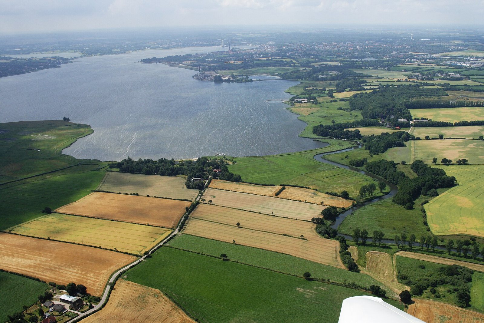
Sliasthorp is the place on the Schlei inlet where, according to the Royal Frankish Annals, the Danish king Godfred gathered his fleet and cavalry in 804 and landed with his whole army in 808 after destroying the trading site of Reric. No written source says exactly where it lay. Since 2010, archaeologists led by Andres Dobat of Aarhus University have been excavating a large elite and garrison site at Füsing, right across the water from Hedeby. Whether Füsing really is Sliasthorp remains a well-argued hypothesis – here is what supports it and what does not.
Picture the Schlei, the long Baltic inlet in today's northern Germany, on a late-summer day in 804. Ships crowd the water. Horsemen gather on the shore. A king has arrived with "his fleet and all the cavalry of his kingdom", as a Frankish annalist would later write. A few days' ride to the south, on the Elbe, the most powerful man in Western Europe is waiting: Charlemagne. The two are supposed to meet. They never will.
The place where the Danish king pitched camp has a name that appears in the sources exactly twice and then all but vanishes: Sliesthorp, today usually written Sliasthorp. Everyone has heard of Hedeby. Sliasthorp, by contrast, was a ghost for a long time – a word in a chronicle with no spot on the map. That changed when a metal detector started beeping on a sandy plateau on the north shore of the Schlei.
Everything the written record tells us about Sliasthorp comes from the Annales regni Francorum, the Royal Frankish Annals. They are the official year-by-year chronicle of the Carolingian court, written from the Frankish point of view. Keep that in mind whenever they speak of "Godofridus rex Danorum" – the king English-language scholarship usually calls Godfred or Gudfred, and German scholarship Göttrik.
Under the year 804 the Annals say Godfred came with fleet and cavalry to a place "qui dicitur Sliesthorp, in confinio regni sui et Saxoniae" – "which is called Sliesthorp, on the border of his kingdom and Saxony". Under 808 the place appears again, this time explicitly as a harbour: after his campaign against the Obodrites, Godfred came "ad portum, qui Sliesthorp dicitur" with his entire army. That is the whole contemporary written record. Two entries, a few lines.
The name itself is easy to unpack. Slie is the Schlei, the inlet running between Schleswig and Kappeln. Thorp is the Old Norse and Old Saxon word for a village or settlement, a cousin of the English place-name element "-thorpe". Sliasthorp means something like "village on the Schlei". Rather modest for a place where a king turns up with his army – and that modesty will become an argument later on.
To understand the first entry, look at the other side of the frontier. Charlemagne had been at war with the Saxons since 772, one of the most stubborn conflicts of his reign. In 804 he brought it to a brutal close. According to the Annals, he deported the Saxons living beyond the Elbe and in the district of Wihmuodi, with their wives and children, into the Frankish realm. The lands north of the Elbe – the region known as Nordalbingia – he handed to his Slavic allies, the Obodrites.
Suddenly the Franks and their allies bordered directly on Danish territory. Godfred answered with a show of force: he marched to Sliasthorp, right on the frontier. Charlemagne was then camped on the Elbe at a place called Holdunsteti. The Annals report that Godfred promised to come to a meeting but, on the advice of his men, stayed away and sent envoys instead. Charlemagne sent messengers of his own demanding the return of fugitives, then went off to Aachen to hunt.
It reads like a diplomatic chess move: stand at the border with your whole army, and still not show up. Presence without risk. Sliasthorp was no random choice either. Whoever gathers an army on the Schlei stands at the narrowest point of the Jutland peninsula, where the land route south and the shortcut between the Baltic and the North Sea come closest together.
Four years later Godfred moved from posturing to striking. Under 808 the Annals report that he crossed into Obodrite territory with an army. The Wilzi, a Slavic group with an old grudge against the Obodrites, joined him of their own accord. Godfred took several strongholds, drove out the Obodrite leader Thrasco, and had another chieftain, Godelaib, captured and hanged. Two parts of the Obodrites were made to pay him tribute.
Then comes the sentence that keeps Sliasthorp interesting to this day. Godfred destroyed a trading place on the Baltic coast which the Danes in their own language called Reric – "distructo emporio" – and removed the merchants from there: "translatisque inde negotiatoribus". After that he broke up his fleet and came "ad portum, qui Sliesthorp dicitur", with his entire army. He stayed there a few days and decided to protect the border of his kingdom against Saxony with a rampart reaching from the eastern bay of the sea to the western ocean, along the north bank of the river the source calls Egidora – the Eider – with just one gate for wagons and riders.
It pays to read this closely, because many retellings – including the earlier version of this very article – simplify it. The Annals do not say in so many words that the Reric merchants were taken to Sliasthorp. They say the merchants were removed, and that Godfred afterwards sailed into Sliasthorp with fleet and army. That the traders ended up on the Schlei and fuelled the rise of Hedeby is an obvious and widely held interpretation. It fits what archaeology shows for Hedeby in the early ninth century. But it is an interpretation, not the wording of the source.
Reric itself is usually identified today with a site near Groß Strömkendorf on the Bay of Wismar, excavated in the 1990s. The latest tree-ring dated timbers there reach 811, so the settlement carried on briefly after 808. That identification, too, rests on location and finds, not on an inscription.
What followed 808 reads in the Annals like an escalation spiral. Charlemagne sent his son, Charles the Younger, to the Elbe with an army. In 809 Godfred sent word through merchants that he had heard the emperor was angry with him and proposed a meeting beyond the Elbe. Frankish and Danish magnates did meet, but nothing was agreed. That same year Thrasco, the Obodrite leader, was treacherously killed by Godfred's men – in the trading place of Reric, of all places. Charlemagne responded by ordering a fortress built north of the Elbe, on the river Stör, at a place the Annals call Esesfelth, usually linked with the area of Itzehoe.
In 810 Godfred hit where it hurt. A Danish fleet of two hundred ships raided the Frisian islands, and the Frisians were forced to pay tribute. Charlemagne mustered an army and marched north. Einhard, Charlemagne's biographer, writes that Godfred regarded Frisia and Saxony "no differently than his own provinces" and boasted that he would soon arrive at Aachen, where the king held court, with great forces. For us in Alsdorf, a short drive from Aachen, that boast has a particular ring – Vikings did eventually reach the palace, but only in 881, as we tell in Vikings in Aachen, 881.
Before the armies ever met, Godfred was killed, according to the Annals, by one of his own retainers. Einhard confirms it in almost the same words. His nephew Hemming took over and made peace with the emperor. In 811 twelve Frankish and twelve Danish nobles met on the Eider and swore to it. The Eider remained the border between the Empire and the North for a long time to come.
After 808 the name Sliasthorp never appears again. Whether it was a permanent residence or a harbour and mustering point Godfred used when needed, the Annals do not say. The phrase "seat of the Danish kings", often repeated online, goes beyond what the source states.
For a long time the simplest answer was: Sliasthorp is Hedeby. The trading town on the Haddebyer Noor appears in later sources under shifting names. In the Life of the missionary Ansgar, written by his successor Rimbert in the ninth century, the harbour where the Danish king allowed a church to be built is called "Sliaswich". Adam of Bremen, writing in the eleventh century, uses Sliaswich and Heidiba side by side, which confused later generations even more once the name Schleswig moved to the new town on the north shore.
Within Hedeby, scholars often pointed to the early so-called southern settlement outside the later semicircular rampart. Others saw Sliasthorp as a forerunner of Schleswig.
There is also a question of wording. In 808 Sliasthorp is called a portus, a harbour, while Reric is explicitly an emporium, a trading place. Why would the chronicler call the most important market on the Schlei by a word meaning "village"? That does not disprove the Hedeby identification – annalists were not pedants about place names. But it leaves room for a separate site.
The small village of Füsing lies on the north shore of the Schlei, east of Schleswig. From its sandy moraine plateau you look straight across to Hedeby and the Danevirke. Water or wet lowland protects it on three sides. About one and a half kilometres to the south lies the Reesholm peninsula, where the Schlei narrows to less than 150 metres.
Stray finds had been noted there since the 1950s. The real breakthrough came in 2003 with systematic metal-detector survey involving Andres Dobat, which revealed a large Viking Age settlement. A geomagnetic survey by Kiel University followed in 2005, along with analysis of aerial photographs. Between 2010 and 2014 four excavation seasons opened up around 12,700 square metres. The project was run by Aarhus University together with the Archaeological State Office of Schleswig-Holstein and the Schleswig-Holstein State Museums Foundation, and funded by the Carlsberg Foundation.
Dobat estimates the settled area at roughly six to eight and a half hectares. For comparison, Hedeby's semicircular rampart enclosed about 26 hectares in the tenth century. Füsing was no second Hedeby – but no farmstead either.
What surprised the excavators most was the sheer number of pit houses: small huts sunk into the ground, typically used in the Viking Age for crafts, storage or simple shelter. Fifty-two were recorded and twenty-five fully excavated. Extrapolated across the plateau, Dobat reckons with 250 to 350 of them. As early as 2012 he suggested many were occupied for only a few weeks a year – a place that filled up at certain times and then emptied again.
Alongside them came about two dozen longhouses, mostly three-aisled – with two rows of internal roof posts – and mostly aligned east to west. There were also pits full of fire-cracked stones and a stretch of palisade on the northern part of the plateau.
The dating is crucial for our question. According to Dobat, settlement began in the second half of the seventh century, around 700 at the latest, and ended in the last decades of the tenth century, by around 1000 at the latest. Pit houses dominate the early phase; longhouses are spread more evenly over the site's life. So Füsing already existed when Godfred came to the Schlei in 804 and 808. It is older than Hedeby's great heyday and fades out roughly when Schleswig, on the north shore, rose to become the new royal and church centre.
The most spectacular building stands on the highest point of the plateau. The excavators call it, prosaically, OA123. It is a hall about 28 to just over 31 metres long and some 8 metres wide, with six pairs of internal roof posts and slightly curved long walls – the classic boat-shaped plan of large Viking Age halls. Early press reports spoke of "over 30 metres". The hall was built on the same spot in two phases and eventually burned down.
And here is the catch that many popular accounts skip: the hall dates to around 900 or the first half of the tenth century. That is about a hundred years after Godfred. Anyone talking about "Godfred's royal hall at Füsing" is mixing up the layers of time. The hall shows that Füsing was still a place with ambition in the tenth century. For the years around 808 it proves nothing.
It does, however, tell a dramatic story of its own. In one entrance post the excavators found a bodkin arrowhead, the narrow armour-piercing type. In the other entrance post lay a caltrop: a small iron device with four spikes that always lands with one point upwards, meant to hamper attackers on foot or on horseback. Dobat describes it as the first of its kind from a securely Viking Age context. Whether the hall really burned in an attack, as early reports suggested, cannot be proven. The finds in the doorposts make the idea far from far-fetched.
A comparison helps. The great royal and cult halls at Tissø on Zealand or at Lejre were considerably larger and grander. Dobat himself stresses that Füsing does not play in that top league. That points more towards a place held by a royal representative – a steward or jarl – than towards a principal residence.
The finds from Füsing are no royal treasure, but they carry a clear signature. Besides at least seven arrowheads, axes and an iron sword pommel, there were Carolingian mounts and a strap end, a gilded mount from a harness or saddle bow, an animal-head mount and a gold arm-ring. These are objects you associate with riders, retinues and prestige.
There are traces of trade and exchange, too: Arabic silver coins known as dirhams, hacksilver – silver chopped up and paid by weight – and weights. A favourite of ours is a seventh-century gold tremissis, a small gold coin later reworked into a cross-shaped pendant. Some 110 glass beads and around 30 shards from at least fifteen drinking glasses point to refined table manners. Quernstones of basalt lava came from the Rhineland. Casting waste, ingots and a touchstone show metalworking on site, and ship rivets hint at shipbuilding or repair.
Andres Dobat published his results in 2022 in the Danish Journal of Archaeology under the telling title "Finding Sliesthorp?" – question mark included. Dagfinn Skre had already proposed a similar identification in 2007. The arguments in favour are solid:
Dobat is just as frank about the weaknesses. There are few radiocarbon dates from Füsing for the ninth century, so the picture is thin precisely for the decisive period. "Village on the Schlei" is an odd name for a seat of power, though not an impossible one. And the buildings do not reach the scale of true royal estates. The identification is therefore explicitly provisional.
Whatever its name, Füsing is a key to understanding the whole landscape. Dobat interprets it as an estate centre and assembly place, but above all as a military base: a seasonally manned garrison and naval station for the defence of the Danevirke. It may also have served as a point where goods changed hands.
The Danevirke itself is older than Godfred. Its earliest phases go back to the second half of the seventh century – the same time Füsing came into being. Around 737, dated by tree rings, a barrier some 1,600 metres long was built in the water at Reesholm, and the Danevirke was substantially reinforced. The Reesholm barrier lies only about one and a half kilometres south of Füsing. So the rampart the Annals credit to Godfred in 808 was no fresh start but the renewal or extension of an older system. Which excavated stretch of wall goes back to Godfred is still not settled.
The result is a picture with three building blocks. Hedeby was the market: crafts, long-distance trade, ships, coins, later walled and hugely expanded. The Danevirke was the bar across the peninsula, with a single passage for the land route now called the Ox Road. And Füsing – perhaps Sliasthorp – was the fortified backstop across the water, where warriors and ships stood ready. Market and power lay close together but apart, within sight of each other.
On the Slavic side of the border, too, strongholds and trade went hand in hand: Starigard in Oldenburg was the centre of the Wagrians and part of the Obodrite world Godfred marched against in 808.
Füsing outlived Godfred by almost two centuries. Around 900 the great hall went up, and eventually it burned. In the last decades of the tenth century the site was abandoned or moved. That coincides with the period when Gorm the Old and Harald Bluetooth reshaped royal power in Denmark. In the eleventh century Schleswig on the north shore took over as the central place; Hedeby was destroyed around 1050 and again in 1066.
The name Sliasthorp disappeared in this transition. It survives in two lines of the Royal Frankish Annals, on a modern memorial stone at Hedeby, and in the debates of archaeologists. Since 2018, Hedeby and the Danevirke have been a joint UNESCO World Heritage Site.
If you want to visit, Hedeby with its museum and reconstructed houses is the natural starting point. From there you look across the Noor and the Schlei towards the north shore. The Danevirke Museum in the village of Dannewerk tells the story of the border rampart. As far as we know there is no reconstruction at Füsing like the one at Hedeby; it is an excavation site in farmland, not an exhibition. More destinations are in our guide Experience the Vikings: Museums and Sites.
What fascinates us is how the pieces fit: a name from the Frankish chancery, a plateau full of pit houses, a burned hall with a caltrop in its doorpost. None of them proves anything on its own. Together they tell a story worth engraving into memory.

What is Sliasthorp? Sliasthorp ("Sliesthorp" in the source) is a place on the Schlei named by the Royal Frankish Annals under 804 and 808 in connection with the Danish king Godfred – in 808 explicitly as a harbour. The name means roughly "village on the Schlei".
Is Füsing the same as Sliasthorp? That is a well-founded hypothesis put forward by archaeologist Andres Dobat, but it is not proven. Füsing fits the Annals well in location, date and finds, yet there is no conclusive link.
How big was the hall at Füsing? The largest hall was about 28 to 31 metres long and around 8 metres wide. It dates to around 900 or the early tenth century, so it is considerably later than King Godfred.
What is the difference between Sliasthorp and Hedeby? Hedeby was the great trading town on the Haddebyer Noor. Sliasthorp appears in the sources as Godfred's harbour and mustering point. The two were long thought identical; today Sliasthorp is more often linked to a separate site such as Füsing.
Did Godfred build the Danevirke? No, the Danevirke is older and goes back to the seventh century. But the Annals report that in 808, at Sliasthorp, Godfred decided to secure the border with a rampart – most likely an extension of the existing system.
Who excavated at Füsing? A team from Aarhus University under Andres Dobat, together with the Archaeological State Office of Schleswig-Holstein and the State Museums Foundation, in four seasons from 2010 to 2014.
For courage. For remembrance. For legends that live on.
Hedeby · The Danevirke · Reric · Nordalbingia · The Ox Road.
All History & Finds articles →
A horse, a golden disc, six little spoked wheels: the Trundholm Sun Chariot is one of the most beautiful images the …
Read more →One late-summer day in 1066, a Norwegian army marched through northern England certain of victory – and a few hours …
Read more →Some lose a battle and thereby win everything. On 29 July 1030 the Norwegian king Olav Haraldsson fell at Stiklestad …
Read more →