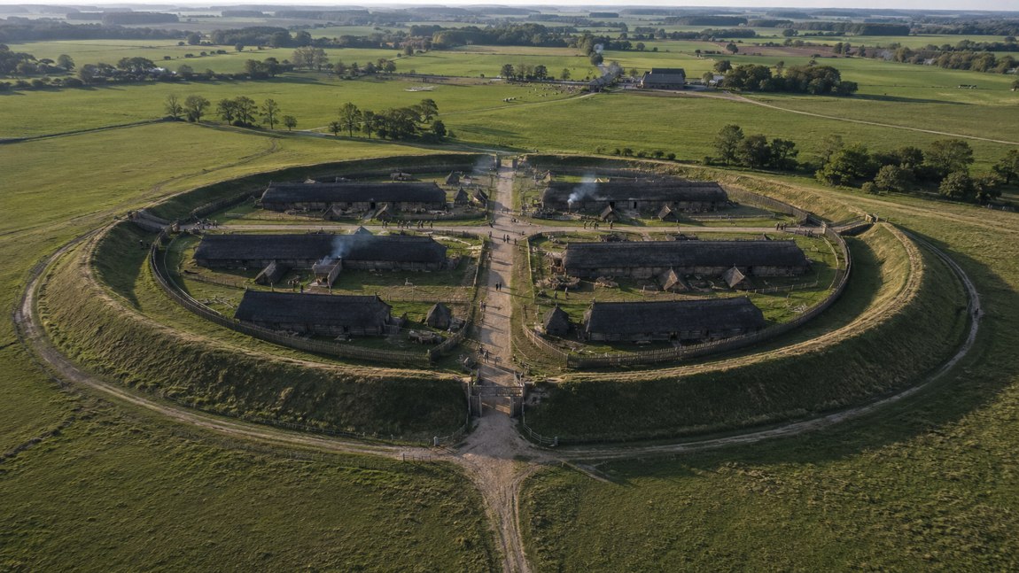
The Danevirke (German Danewerk, "work of the Danes") is a system of ramparts, ditches, walls and a sea barrier near Schleswig in northern Germany, roughly 30 kilometres long in total, that sealed off the narrowest crossing between the Baltic and the North Sea. It was not built in one go but over more than 500 years: securely from the late 7th century, with a major phase in 737, extensions under Harald Bluetooth around 968 and a brick wall around 1170. Since 2018 it has been a UNESCO World Heritage Site together with Hedeby. Here is what tree rings, excavations and chroniclers tell us.
Picture a rampart that was already old when the first Viking ships landed at Lindisfarne in 793. Now picture the same rampart with cannon behind it in the winter of 1864. The Danevirke is not the monument of a single age. It is an archive made of earth, timber, fieldstone and brick, and every generation that used it left its own layer behind.
The best part: this archive is not in Scandinavia. It lies in Schleswig-Holstein, Germany's northernmost state, between the town of Schleswig and the village of Hollingstedt. Much of what is said about it online is legend, and some of it is simply out of date. So let's sort it out: what the ground tells us, what contemporary writers tell us, and what later chroniclers made up.
To understand the Danevirke, start with a map. Nowhere is the Jutland peninsula easier to cross than near Schleswig. From the east, the Schlei, a long and narrow inlet of the Baltic, cuts deep inland. From the west, the rivers Eider and Treene reach in with their wet lowlands and bogs, which in the Viking Age were waterlogged and hard to cross. Between them lies a dry land bridge only a few kilometres wide.
That gap is the whole point. Anyone coming north overland into Jutland had to pass through it. And anyone who wanted to move goods between the Baltic and the North Sea without sailing round the dangerous northern tip of Jutland could unload on the Schlei, cart the cargo overland to Hollingstedt on the Treene and ship it on via the Treene and Eider to the North Sea. As the crow flies, the distance between the Schlei shore at Hedeby and Hollingstedt is about 15 kilometres.
The Danevirke uses this landscape cleverly. It does not block the whole peninsula, only the dry ground. Where bog and water stopped an army anyway, no rampart was needed. That is why on a map the Danevirke looks less like a straight wall and more like a bundle of separate lines: the Main Rampart, the Crooked Rampart, the North Rampart, the East Rampart, the Connecting Rampart, the Kovirke and a barrier in the waters of the Schlei.
The name is simple and confident. Danevirke, Old Danish Danæwirki, means roughly "the Danes' work", in the sense of a fortification. According to the Danish encyclopaedia Lex.dk, that form of the name only appears in writing in the 12th century, long after the oldest parts were built. The Frankish annals of the 9th century never name the rampart; they simply call it a vallum, a wall.
One word of caution: "the border of Denmark" makes you think of barriers and passport control. Nothing like that existed in the 8th century. The Danevirke marked a fortified zone at the southern edge of a realm whose extent changed over the centuries. South of it lay the contested borderland of Nordalbingia, fought over by Saxons, Franks, Slavs and Danes. Interestingly, when the Royal Frankish Annals name a frontier in 811, it is not the rampart but the river Eider: twelve Frankish and twelve Danish nobles met there to swear peace.
The building history of the Danevirke is one of the best-researched topics in northern European archaeology, and it is still not settled in every detail. The key excavations were led by Herbert Jankuhn in the 1930s, by the Danish archaeologist H. Hellmuth Andersen from 1969 to 1975 and later, and since 2010 by the Archaeological State Office of Schleswig-Holstein together with Museum Sønderjylland. At the Main Rampart alone Andersen identified a whole sequence of successive phases.
Two dating methods do the heavy lifting. Dendrochronology matches the tree rings of building timber against a reference curve and, at best, gives the exact year the tree was felled. Radiocarbon dating (C14) measures the decay of carbon in organic material and only gives ranges of several decades. Together they give this picture:
| Section / phase | Date | Type of evidence |
|---|---|---|
| Oldest earthen ramparts at the Main Rampart | secure late 7th c.; origins in the 5th/6th c. debated | radiocarbon, stratigraphy |
| Crooked Rampart westwards towards Hollingstedt | probably c. 700 (uncertain) | construction, stratigraphy |
| Palisade rampart with timber front, North and East Ramparts | 737 | dendrochronology |
| Sea barrier in the Schlei | c. 740 / 8th c. | dendrochronology, diving surveys |
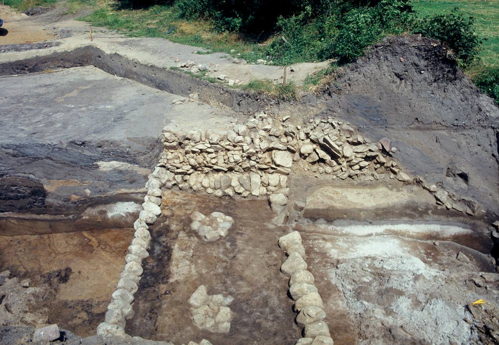
| Fieldstone wall in front of the Main Rampart | 8th c. | excavations 1983 and 2010–2014 |
| Connecting Rampart to Hedeby | 964/65–968 | dendrochronology |
| Kovirke (straight line further south) | 2nd half of 10th c. (disputed) | radiocarbon |
| Valdemar's Wall in brick | c. 1170 | written source, construction |
The very first spade in the ground is still a matter of debate. Lex.dk puts the start around 450 and "certainly before 500", and radiocarbon dates from the excavations at the gate point the same way. The state's cultural landscape portal KuLaDig is more careful and says the Main Rampart existed "at least since the late 7th century". We side with caution. What is certain is that the Danevirke is older than the Viking Age, which is conventionally dated from 793.
The year 737 is the Danevirke's most famous date, and it does not come from a chronicle. It comes from the wood itself. In that year the oaks were felled that went into the palisade and the heavy timber front of the Main Rampart. At the so-called Thyraborg, an artificial platform at the eastern end of the Main Rampart by the former lake of Dannewerk, Andersen found a timber box construction in 1972 with the same date.
At almost the same time the North Rampart was built, as was the East Rampart, which cut off the Schwansen peninsula between the Schlei and Eckernförde Bay. Then there was a barrier in the water itself: the sea barrier in the Schlei, a line of piles and timber structures meant to keep ships out. From 1992 onwards, German army divers helped the archaeologist Willi Kramer survey it underwater.
What does this mean historically? Whoever could fell hundreds of oaks, shift thousands of cubic metres of earth and feed a workforce for months in 737 held real power. The Danevirke is one of the earliest signs of supra-regional rule in southern Scandinavia. The trouble is that no source names the builder. In his Life of the missionary Willibrord, Alcuin mentions a Danish king called Ongendus, whom Willibrord is said to have visited early in the 8th century. Whether Ongendus or one of his successors ordered the work of 737 cannot be proven. It is a tempting guess, nothing more.
The first time anyone writes about the Danevirke is in 808. The Royal Frankish Annals (Annales regni Francorum) were a kind of official year-by-year record kept at the court of Charlemagne. Once Charlemagne had conquered the Saxons, his empire bordered directly on the Danes. The Annals call their king Godofridus; in English you will usually see Godfred or Gudfred.
As early as 804 Godfred had come with his fleet and cavalry to Sliesthorp, "on the border between his kingdom and Saxony". Most scholars now place Sliesthorp at Sliasthorp near Füsing on the Schlei, while others look for it at Hedeby. In 808 Godfred attacked the Obotrites, Slavic allies of the Franks, destroyed their trading place Reric, took its merchants with him and marched his whole army to Sliesthorp. There, the annalist says, he decided on the rampart:
"… he resolved to fortify the border of his kingdom facing Saxony with a rampart, so that a protective bulwark would stretch along the whole northern bank of the Eider, from the eastern bay of the sea which they call Ostarsalt as far as the western ocean, leaving only a single gate through which wagons and horsemen could be let out and in."Annales regni Francorum, year 808 (public-domain Latin text, our own translation)
This passage is a gift, because it gives purpose and design in one sentence: a defence against the south, a line from the Baltic inlet to the North Sea, and a single gate for wagons and riders. It is also a puzzle. So far, archaeologists have not been able to tie any building phase firmly to 808. Godfred may have had existing ramparts repaired and strengthened, and the Frankish writer turned that into a new build. Or the work of 808 left traces that cannot yet be assigned with certainty, perhaps in the Kovirke or the fieldstone wall. The honest summary is this: the Annals record a decision to build in 808, and the ground records a rampart that was by then at least seventy years old.
Godfred was an aggressive ruler. According to the Annals he boasted that he would soon march on Aachen with an army. He never did: in 810 he was killed by one of his own retainers. His nephew and successor Hemming made peace with Charlemagne in 811, at the Eider.
One phrase in the Annals intrigued researchers above all: "only a single gate". Where was it? It had long been suspected at the point where the old north–south route through Jutland, the Army Road (Danish Hærvejen) or Ox Road, crosses the Main Rampart. The name Ox Road comes from a later period, when large herds of cattle were driven south along it in the late Middle Ages and early modern times. The route itself is far older.
In 2010 a team from the Archaeological State Office led by Astrid Tummuscheit found a gap in the fieldstone wall at exactly this spot near Dannewerk. Further seasons in 2013 and 2014, together with Frauke Witte of Museum Sønderjylland, brought the picture into focus:
The excavators identify the gap with the "single gate" of the Annals. That cannot be proven beyond doubt, since a gateway carries no inscription. But location, age and use fit remarkably well. In medieval sources the passage appears under names such as Wiglesdor (Danish Viglesport) or Kalegat. Newer excavations in 2024/25 near the museum revealed an older stone setting beneath the rampart and a post structure that predates the oldest ramparts, a sign that this story is far from finished.
The obvious answer is defence. A rampart with a palisade and ditch will not stop a determined army forever, but it forces the enemy to regroup, buys time and funnels attackers towards a few points. In an age when cavalry and baggage trains depended on roads, that was worth a great deal.
Just as important was control of traffic. If there was only one gate for wagons and riders, the king knew who was entering his land. The overland route from the south and the cross-route between the Baltic and the North Sea met here. It is highly plausible that dues were collected at such a bottleneck, and many accounts speak of tolls at the Danevirke. However, we know of no contemporary source that explicitly mentions a toll at the Danevirke gate in the 8th or 9th century. What is documented is the economic link: in 808 Godfred moved the merchants of Reric closer to him, and Hedeby flourished in the decades that followed.
And finally the Danevirke was a statement. A structure on this scale told everyone who saw it that here began a realm that was organised and could command labour. Rampart and royal power went hand in hand.
In the 10th century the focus shifted. Hedeby, on the western shore of the Haddeby Noor, had become the largest trading town in the North. It received its own semicircular rampart, a little over a kilometre long, whose exact date is disputed. Then the Connecting Rampart was built, linking Hedeby's semicircular rampart to the Main Rampart. The tree rings point to 964/65 to 968. The king at that time was Harald Bluetooth, the same ruler who boasted on the great Jelling stone that he had won all of Denmark and made the Danes Christian.
Harald built on a grand scale. The same decades saw the palisade at Jelling, the Ravning Enge bridge and the Trelleborg ring fortresses. The Danevirke fits that programme: Harald tied the most important trading town of his realm firmly into the border system. Opinions differ on the Kovirke, a dead-straight rampart and ditch south of the Main Rampart. Lex.dk cites radiocarbon dates between 770 and 970, while German research tends towards the second half of the 10th century, possibly under Harald as well.
The extension did not always help. In the autumn of 974 Emperor Otto II broke through the Danevirke and had a fortress built there. For nearly a decade the area around Hedeby was under Ottonian control, until the Danes won it back in 983 during the great Slavic uprising. By the way, if you connect your headphones wirelessly today, you are using Harald's nickname. Find out why in Your phone carries a Viking king.
The Viking Age was long over when the Danevirke took on its most impressive form. King Valdemar I the Great (reigned 1157–1182) had a wall of fired brick set in front of the Main Rampart around 1170, about four kilometres long. It is among the earliest brick buildings in Denmark. How tall it originally stood can only be estimated; figures of around seven metres circulate, but they are reconstructions.
How do we know Valdemar built it? From his own grave. In the church at Ringsted on Zealand a lead plaque was found that had been laid with him, recording the building of this wall among his deeds. It is a rare case of a medieval king taking his building project with him to the grave.
Today most of Valdemar's Wall lies hidden under earth and vegetation. In the archaeological park by the museum, a stretch of about 80 metres has been exposed. Standing in front of it, you are not looking at the Viking Age but at the High Middle Ages, and you realise how long this place was thought of as a frontier.
No Danevirke story is better known than that of Thyra Danebod, wife of Gorm the Old and mother of Harald Bluetooth. Two Danish historians of the late 12th century tell it. In Sven Aggesen's version, Thyra is a noblewoman whom the German emperor marries to Gorm so that she can collect the Danes' tribute for him. Instead she refuses to pay and has the Danevirke built, telling the emperor the wall is meant to protect Germany from Gorm. In Saxo Grammaticus she is the wise and steadfast queen who secures the land against attacks from the south. Later chroniclers embroidered the tale, and in the 19th century the painter Lorenz Frølich showed Thyra as the builder.
Why has the legend proved so durable? Because it is a great story: a clever woman outwits an emperor and protects her people. It is not worthless, though. It shows how strongly the Danevirke was already tied to the idea of an independent Danish kingdom in the Middle Ages.
In the 19th century the old rampart made an unexpected comeback. After the Schleswig-Holstein uprising of 1848 and the war that lasted until 1850, Denmark turned the Danevirke into a modern defensive line with artillery redoubts from 1861 onwards. Those earthworks also marked the start of archaeological research on the rampart. Even earlier, the theologian and poet N. F. S. Grundtvig had published a journal called Dannevirke; the rampart had become a national symbol.
The test came in the Second Schleswig War of 1864. On 1 February Prussian and Austrian troops crossed the Eider, and on 2 February there was fighting at Mysunde on the Schlei. But the winter was hard, the Schlei and the lowlands froze, and the position was in danger of being outflanked. General Christian Julius de Meza had the Danevirke evacuated on the night of 5 to 6 February 1864, and the army withdrew to Dybbøl. The Danish public, which had believed the rampart impregnable, was shocked, and de Meza was relieved of his command.
Since then the Danevirke has been on German soil. For the Danish minority in South Schleswig it has remained a place of memory. Today German and Danish archaeologists dig side by side on the rampart, a quiet but fitting twist to this story.
In the summer of 2018, at its session in Manama, Bahrain, the UNESCO World Heritage Committee inscribed the "Archaeological Border Complex of Hedeby and the Danevirke" on the World Heritage List. For Schleswig-Holstein it was the third World Heritage Site, after the old town of Lübeck and the Wadden Sea. The site has several components: the Crooked Rampart, Main Rampart, North Rampart, Connecting Rampart, Kovirke, East Rampart, the underwater barriers, and Hedeby with its semicircular rampart, harbour, cemeteries, hillfort and three runestones.
The inscription rests on two criteria: the complex is exceptional evidence of exchange between the Continent and Scandinavia and between the North Sea and the Baltic, and it is an outstanding example of an early medieval border landscape. One detail we love: about 95 per cent of Hedeby has never been excavated.
A note for honesty's sake: the redoubts of 1861–1864 that you can still see along the Main Rampart are part of the story, but they are not Viking Age. They are the only parts that have been partly restored in modern times, and they can be told apart from the older ramparts.
The Danevirke is freely accessible and easy to explore on foot or by bike. Footpaths follow the Main Rampart and the Connecting Rampart, and information boards explain each section. The main starting point is the Danevirke Museum in Dannewerk, right on the old Ox Road and next to the gate in the rampart. The old museum building, a former farmhouse, was demolished in 2022; since then the exhibition has been running in a temporary building while a new museum and a redesigned archaeological park are being built. Check the museum's website before you go for the current situation.
The Viking Museum Hedeby is only a few kilometres away, and the Connecting Rampart is the nicest way to walk there. For more places to visit, see our guide Viking museums and sites from Hedeby to Lofoten, and to see how other fortifications of the period were built, read our piece on forts and ramparts of the Viking Age.

How old is the Danevirke? The Main Rampart is securely dated to at least the late 7th century, with a major palisade phase in 737. Whether the oldest earthworks go back to around 500 is debated; the last medieval phase is Valdemar's Wall of around 1170.
How long is the Danevirke? All the ramparts together are about 30 kilometres long. The Main Rampart alone is about 5.5 kilometres, the Crooked Rampart about 7.5 kilometres.
Who built the Danevirke? We do not know who started it. According to the Royal Frankish Annals King Godfred had it fortified in 808, Harald Bluetooth built the Connecting Rampart around 968 and Valdemar I added the brick wall around 1170. Queen Thyra's role is a legend.
Where can you see the Danevirke? Best at Dannewerk, just west of Schleswig, around the Danevirke Museum. There you can see the Main Rampart, the gate on the Ox Road and an exposed stretch of Valdemar's Wall.
Is the Danevirke a UNESCO World Heritage Site? Yes, since 2018, together with Hedeby as the "Archaeological Border Complex of Hedeby and the Danevirke".
Why did the Danevirke not hold in 1864? Because of frost and the risk of being outflanked. The frozen Schlei could be crossed, and General de Meza abandoned the position without a battle in early February 1864 to save the army.
For courage. For remembrance. For legends that live on.
Hedeby · Viking traces in Germany · The North Frisian ring forts · Reric · The Ox Road.
All History & Finds articles →
In 723 an Anglo-Saxon missionary stood axe in hand before the holiest tree of the Hessians – the oak sacred to the …
Read more →Vikings were not only raiders. In the Rhine-Meuse delta they sat in the very middle of the greatest trading centre of …
Read more →Some 1,700 years ago a man from the Near East settled in a Germanic village in present-day Thuringia – and rose into …
Read more →