The North Frisian ring forts are massive circular earthen ramparts on the islands of Sylt and Föhr – chief among them the Tinnumburg near Tinnum and the Lembecksburg (also called Borgsumburg) near Borgsum – and their story is older and more tangled than the label "Viking fortress" suggests. Some began in the Roman Iron Age around the start of the Common Era, they were reoccupied in the early Middle Ages, and in the Borgsumburg timbers date the latest phase to around 980 – the very years when Harald Bluetooth was building his Trelleborg fortresses in Denmark.
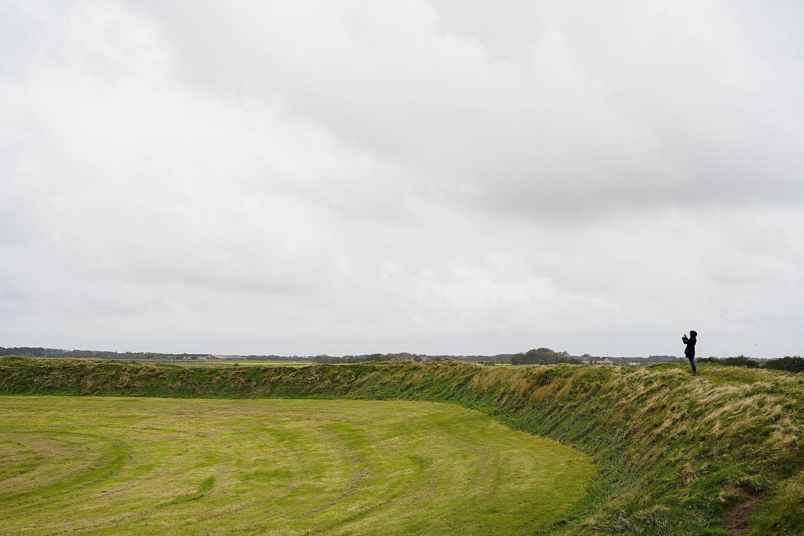
Picture a grey November afternoon on Föhr. The wind comes off the North Sea, the marsh north of the village of Borgsum lies flat as a tabletop, and out of it rises a green ring almost eight metres high. Climb the rampart and you can see across the island to the tidal flats. Beneath your boots lie roughly a thousand years of island life, layer upon layer: turf, hearths, loom weights, feathers, eggshells. Yes, eggshells.
The ring forts of the North Frisian islands are among the most striking earthworks on Germany's North Sea coast. For a long time they were explained as refuge forts – places where islanders herded their cattle and carried their valuables when Viking sails appeared on the horizon. That picture is not wrong. It is just far too small. New excavations, geophysical surveys and tree-ring dates tell a richer story: Iron Age earthworks, Frisian settlers, a garrison packed into turf-walled houses, and a possible link to a Danish king. As always, we keep three things apart: what has been dug up, what researchers infer from it, and what later legend has added.
A ring fort is a circular or oval rampart of earth, sand or turf, usually with a ditch in front and one or more gates. Archaeologists also call such sites earthworks or hillforts, even when there is no hill. The circle has a plain practical advantage: it encloses the largest area with the shortest wall, and every stretch of the rampart can be defended equally well. On the islands there was a further reason to build this way. Stone and good timber were scarce, but turf from the marsh was everywhere. Cut sods were the building material of this landscape, for ramparts and houses alike.
The locations are not random. The ring forts sit where the higher, sandy geest – the glacial core of each island – meets the low-lying marsh, the fertile land built up from marine sediments. Before the dikes, tidal creeks reached right up to these geest edges. A rampart here stood on firm ground, had grazing at its feet and, in some cases, a channel out to open water. Both the Tinnumburg and the Borgsumburg are thought to have had such a navigable approach.
Three sites are well known: the Tinnumburg and the Archsumburg on Sylt, and the Lembecksburg on Föhr. A fourth, the Rantumburg on Sylt, is reported in older accounts to lie buried under dunes. One point trips up many searches: the "Borgsumburg" is not a separate fort. It is the same rampart as the Lembecksburg. Researchers today prefer to name it after the village of Borgsum, because "Lembecksburg" comes from a late legend, which we will come to.
And Amrum? No comparable ring fort survives or has been securely identified there. A field name "Bey der Burch" from 1629 and a "Burg Borragh" on a map of 1652 near Norddorf hint at some kind of fortification, but the spot has never been excavated and is more likely late medieval.
The Tinnumburg – in Sölring, the Frisian dialect of Sylt, simply Borig, "the fort" – lies south of Tinnum at the edge of the marsh. The rampart is about 120 metres across, up to roughly seven metres high and some 440 metres round. There were gates at least on the east and south, with a possible third on the west. Until the marsh was diked in 1938, the ring stood out of the water like a small island during storm floods. To the north-west a tidal channel ran out to the Wadden Sea, and beside the fort lies a small lake, the Döplem.
The site was dug in 1870, 1948 and 1976. The 1948 trench hit a waterlogged cultural layer about 1.8 metres thick inside the ring, with iron fragments, worked wood and pottery of the late Viking Age. The work of the 1970s belonged to the large Archsum research project, published by Ole Harck in 1990. His volume deals explicitly with the "Roman-period earthworks" of Archsumburg, Tinnumburg and Trælbanken.
When that second use began is still debated. Standard overviews give the 8th to 10th centuries. Bente Sven Majchczack and colleagues, writing in 2020, place both the Tinnum ring fort and the Borgsumburg in the first half of the 8th century – roughly the time of the first major phase of the Danevirke. That date draws on the new fieldwork around Föhr; for Tinnum itself it has not yet been tested by a modern large-scale excavation.
The surroundings are just as telling. About a kilometre away lay a settlement of sunken-floored buildings – small workshops and dwellings dug into the ground – starting shortly after the middle of the 7th century. People there worked amber and made glass beads. Finds include loom weights, whetstones from Norway and a brooch in the Borre style, a Scandinavian animal-ornament style of the 9th and 10th centuries. Sylt was no remote sandbank, but a knot in the North Sea network. For more on the "gold of the North" see our article on amber.
A few kilometres east stood the Archsumburg. It has been largely levelled and is barely recognisable on the ground today. Its diameter was around 85 to 90 metres. Harck's excavations in the 1970s revealed traces of radially arranged houses inside – buildings pointing towards the centre like the spokes of a wheel. The Archsumburg is dated to the Roman Iron Age, in most accounts to the 1st century AD.
A close counterpart lies on the mainland: Trælbanken, in the marsh north of Højer in South Jutland, a ring of similar size but with no proven internal buildings. Harck investigated it together with the two Sylt forts. Together they form a group of Roman Iron Age earthworks along the west coast of old Schleswig whose purpose is still discussed. Danish accounts tend to link them with other ramparts and sea barriers of the period in Jutland. Whether they served as refuges, military bases or assembly places cannot be settled for that early phase.
The Borgsumburg stands about a kilometre north of Borgsum on a small geest knoll at the edge of the marsh. With an internal diameter of almost 100 metres and a rampart nearly eight metres high, it is the most imposing of the North Frisian rings. A gate opens to the south; in front of the eastern side lie a low outer bank and a shallow ditch. To the north, marshy ground once gave extra protection.
The first sizeable excavation took place inside the ring in 1951–52. It uncovered several simple turf-walled houses aligned radially to the rampart. Their gable doors opened onto a paved path, and a well lay nearby. The finds – pottery of the so-called North Sea group, loom weights, iron tools, soapstone vessels and imported Pingsdorf ware from the Rhineland – placed the buildings between the 9th and the late 10th century. Sherds from the Neolithic and the Iron Age also turned up, showing that people had used the knoll long before. In 1961 Peter La Baume summed up the state of knowledge under the candid title "What do we know about the Lembecksburg?" The answer back then was: not much.
That changed in two steps. In 2001 and 2003 the fort was surveyed with magnetometry and ground-penetrating radar. The images showed many turf houses packed tightly along the inner face of the rampart, strikingly uniform and radial. Since June 2021 the Lower Saxony Institute for Historical Coastal Research (NIhK) has been excavating there, directed by Martin Segschneider with Kirsten Hüser leading the fieldwork, funded by the Frederik Paulsen Foundation. A geoarchaeological doctoral project with Kiel University studies the landscape around the fort; its cores have traced a ditch at the gate and old water bodies in the marsh.
The new trenches confirmed what the survey had suggested: houses stood shoulder to shoulder, radial to the rampart, with hearths and a cistern for water. Because the ground is so wet, organic material has survived remarkably well – textile fragments, animal bones, spindle whorls, loom weights, bird remains with feathers, and those eggshells. A well-preserved 10th-century pot points to links with Hedeby. No timber palisade has been found on the crest of the rampart so far; instead the excavators suggest a walkway along the top, sheltered on both sides by low turf walls.
And the rampart itself – how old is it? This is where it gets tricky. In 1978 the prehistorian Gerhard Mildenberger thought it possible that the Lembecksburg, like Archsum and Tinnum, went back to the Iron Age. Majchczack and colleagues put the start of the radial houses in the first half of the 8th century. Hüser and Segschneider describe the phase around 980 as the refurbishment of a ring that already existed. There is, in short, no construction date yet for the first rampart. That is the most exciting open question about the site.
The function of the North Frisian ring forts is not a puzzle with one solution but one with several answers, depending on the century. Three readings are on the table.
Refuge fort. The classic explanation: in times of danger, people from the surrounding farms withdrew behind the rampart with livestock and stores. The forts' position at the edge of settled land and their large interiors support this. But for the early Middle Ages the excavations argue against it. A refuge normally stands empty. At Borgsum, closely packed, uniform houses stood for generations and left four metres of deposits. That is no shelter for a few anxious days.
Cult site. For the Roman-period Tinnumburg a ritual interpretation has been proposed, and it appears in handbooks on early Germanic religion. The main argument is that no ordinary settlement could be identified in the older earthwork. A rampart without houses but with meaning recalls the assembly and offering places known elsewhere in the Germanic world, as in our piece on Germanic offerings and sanctuaries. A clear offering deposit like those from the great bogs is missing, though. The cult idea remains a possibility, not a result.
Garrison and protection of trade. For the early medieval phases, Majchczack and colleagues read the uniform, radial houses as a military garrison controlling the island and the nearby trading places. The finds suggest a seafaring crew that may not have been local. That fits what lies in the ground around the fort.
These readings do not cancel each other out. A rampart can be a gathering place in the Roman Iron Age, a garrison base eight hundred years later, and still a refuge when trouble comes.
After a gap of about 150 years, the North Frisian islands were resettled around the middle of the 7th century, probably by Frisians from the southern North Sea coast. What they built was surprisingly well connected.
Witsum on Föhr, about 1.2 kilometres south of the Borgsumburg, was a village of some ten hectares. A reused well timber gives a felling date of around 697. Its main phase lies in the 8th and 9th centuries. People wove and worked amber in sunken huts, used quernstones of Rhenish basalt lava and slate from Norway, and owned glass beads resembling those made in Ribe.
Goting on Föhr's south coast was a site of sunken huts with its own workshop area by the shore. Smithing waste and boat rivets point to boats being repaired or built. A hoard of 87 coins from the early 8th century points to West Frisian traders. In the 9th century the picture shifts: beads from the Near East appear, and the route via Hedeby to the Baltic gains weight.
Ribe was probably the main market for the islands' surplus in the 8th and 9th centuries. A garrison behind the rampart therefore sat on a trade route linking the Rhine, Jutland and the Baltic. Our article on Viking trade follows those routes further.
Who controlled the islands in the 9th and 10th centuries? The honest answer is that we do not know exactly. The population was Frisian in character, and so is the language to this day – Sölring on Sylt, Fering on Föhr, Öömrang on Amrum. Politically, though, the coast north of the Eider lay within the reach of the Danish kings.
One written source shows how fluid this was. According to the Annals of Fulda, in 857 the Dane Rorik received, with the Danish king's consent, a part of the kingdom "between the sea and the Eider". The same Rorik was at times a Carolingian vassal in Frisia, with Dorestad as his base – a story we tell in our piece on Dorestad and Rorik. How the borderland south of the Eider was organised against the Franks is covered in our article on Nordalbingia.
Majchczack and colleagues think it possible that the North Frisian coast was tied into a Danish-controlled system of border defence connected with the Danevirke. They present this explicitly as a possibility. Older literature also noted that the island forts find their closest parallels in form along the southern North Sea coast rather than in Denmark. In Zeeland, on Walcheren, round forts were indeed built against the Vikings in the late 9th century, for example at Oost-Souburg. The North Frisian rings thus stand between two worlds: Frisian in building tradition, perhaps Danish in the order of power.
The latest phase of the Borgsumburg, around 980, invites a comparison the excavators drew themselves. Their paper is titled "Greetings from Harald Bluetooth?" – with a question mark, and rightly so.
In exactly those years Harald Bluetooth had a series of strictly geometric ring fortresses built in Denmark. At Trelleborg on Zealand, tree-ring dating shows timber felled between August 980 and May 981. The group also includes Fyrkat, Aggersborg, Nonnebakken in Odense and Borgring near Køge, discovered only in 2014. These forts were apparently used only briefly; the National Museum of Denmark estimates around ten to fifteen years for Trelleborg. Since 2023 they have been a UNESCO World Heritage Site.
What Borgsum shares with them: a circular rampart, timber-and-earth construction, a date around 980 and an organised, uniform interior. The differences, however, are clear:
Hüser and Segschneider put it cautiously: around 980, people may have preferred to refurbish an existing ring rather than build a new one. If so, the Borgsumburg would be a kind of "Trelleborg light" in the Wadden Sea – one link in Harald's chain of power, built from Frisian turf. This cannot yet be proven. What we have is a tree-ring date that fits the period very well. For an overview of the fort types of the age, see our guide to Viking Age fortifications.
That leaves the name. On Föhr people tell – and this is explicitly a legend – that a knight called Klaus Lembeck held the fort. King Valdemar IV of Denmark, known as Atterdag, besieged him with an army. When the Frisians of Föhr went over to the king, Lembeck had to flee.
There was a real Claus Limbek, a 14th-century nobleman and one of the leaders of the opposition to Valdemar IV. His known seat, however, was on the mainland, at Tørning castle west of Haderslev. That he ever set foot on Föhr is not documented. One tradition reports that in 1377 his son Henneke Limbek landed on the island with an army and killed the bailiff. Where Henneke's stronghold stood is unclear; a site near Süderende, now built over, is suspected and is referred to as "Henneke Lembek's castle". The great Borgsumburg, by contrast, seems to have been abandoned from the mid-11th century according to the archaeology.
So the legend explains the name, not the monument. It still has value: it shows how later generations filled a vast, puzzling structure with the history they knew. Our guide to Norse legends collects more such stories.
Tacitus is often brought into any discussion of these islands. In his Germania (chapter 40, around AD 98) he describes several tribes, among them the Angles and the Varini, who jointly worship Nerthus. In our own rendering:
Together they worship Nerthus, that is, Mother Earth, and believe that she intervenes in human affairs. On an island in the Ocean there is a sacred grove. Tacitus, Germania 40, our own translation from the public-domain Latin text
Nobody knows which island Tacitus meant. Zealand, Fehmarn, Als and North Sea islands have all been suggested; none is proven. Nor can we say whether the builders of the Roman-period Tinnumburg belonged to any of the tribes he names. The connection is tempting but speculative. More on the Nerthus peoples can be found in our article on the Varini.
The Tinnumburg is freely accessible and an easy walk from the edge of Tinnum. You can walk the full circuit along the crest. The Lembecksburg north of Borgsum is open as well and, with its steep, unbroken bank, feels even more impressive. During excavation seasons the trenches are of course fenced off – and please: finds belong with the state archaeology office, not in your pocket. Of the Archsumburg there is hardly anything to see.
If you are looking for more places where the Viking Age can still be touched in northern Germany, try our overview of Viking traces in Germany and our guide to museums and sites.
What fascinates us in the workshop about these ramparts is simple: they were built from turf, the material lying right outside the door, and they have still lasted two thousand years. That is the kind of permanence we look for in slate and wood.
How old is the Tinnumburg on Sylt? The first earthwork was built around the start of the Common Era, in the early Roman Iron Age. The rampart visible today belongs to an early medieval reuse dated, depending on the author, between the 8th and 10th centuries.
Are the Lembecksburg and the Borgsumburg the same fort? Yes. Both names refer to the ring fort north of Borgsum on Föhr. "Lembecksburg" is the popular name from a legend; "Borgsumburg" is the name used by archaeologists.
Were the North Frisian ring forts Viking forts? Only in part. The Sylt forts are centuries older than the Viking Age. The Borgsumburg, however, was intensively occupied during the Viking Age, and its latest phase dates to around 980.
Did Harald Bluetooth build the Lembecksburg? No, the rampart already existed. The excavators think it may have been refurbished around 980 as part of Harald's fortress-building programme, but that remains a hypothesis.
Is there a ring fort on Amrum? No comparable early medieval ring fort is known on Amrum. The "Burg Borragh" near Norddorf is known only from field names and old maps and has never been excavated.
Can you visit the North Frisian ring forts? Yes, the Tinnumburg and the Lembecksburg are freely accessible monuments. Parts may be closed while excavations are under way.
For courage. For remembrance. For legends that live on.
Viking traces in Germany · Hedeby · Trelleborg – Harald's ring fortresses · The bog army-offerings · The longships.
All History & Finds articles →
While Uppsala is famous above all from a text, Thuringia holds the best-excavated Germanic sanctuary in the ground: the …
Read more →Long before there were Germanic peoples – some 4,300 years ago – people in today’s Saxony-Anhalt raised a vast ring of …
Read more →King Hákon the Good, a son of Harald Fairhair, fought all his life against the sons of his brother Eric Bloodaxe. Two …
Read more →Long before there were Vikings in the sense of the sagas, there was already a town in south-west Jutland: Ribe, founded …
Read more →