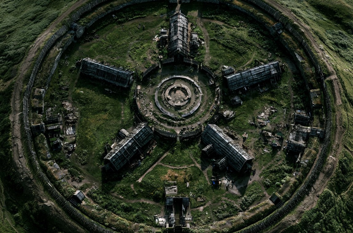
Borgring is a circular Viking Age ring fortress at Lellinge, just west of Køge on the Danish island of Zealand – the fifth known Trelleborg-type fortress in Denmark, tracked down in 2013–14 by Søren Sindbæk and Nanna Holm using a LiDAR elevation model and magnetic survey. It was built in the second half of the tenth century, in the reign of Harald Bluetooth. Three of its four gates burned, no houses stood inside, and much suggests it was never finished. It became UNESCO World Heritage in 2023 and has had its own museum since 2025.
Picture a field outside the village of Lellinge, a short drive from Køge. A stream in the valley, a low hump that farmers have ploughed over for generations. Nothing that would make you stop the car. Yet just beneath the topsoil lay one of the most ambitious building sites of medieval Denmark: a circle almost 145 metres across, laid out as if with a pair of compasses, with four gates set at perfect right angles. It was not a spade that found it. It was a computer and a cloud of laser points.
Borgring is the most recent addition to Harald Bluetooth's famous ring fortresses, and quite possibly the strangest. No longhouses. Burnt gateways. A buried tool chest. A scrap of silver that points to a seeress. Here is what the excavations of 2014 to 2018 actually found, where the experts are still scratching their heads – and how you can walk the rampart yourself today.
The story is one of near misses. As early as 1682 the field name "Borrering" turns up in the land survey made under King Christian V. In 1875 the National Museum recorded the mound beside the Køge Å river as a "borgbanke", a castle mound. An aerial photograph taken in snow in 1970 showed a raised feature, but not its shape. In 1971 and 1972 the National Museum, under Thorkild Ramskou, actually dug into the bank. The trenches produced pits and settlement traces from the Roman Iron Age, the first centuries AD. The excavator's conclusion: the rampart had nothing to do with the Viking Age. And there the matter rested.
Then came LiDAR. Denmark had its entire territory scanned from the air with lasers, producing a national elevation model in which even gentle bumps invisible on the ground stand out. In 2013 the archaeologist Nanna Holm, then at Danmarks Borgcenter in Vordingborg (now part of Museum Southeast Denmark), and Søren M. Sindbæk, professor of archaeology at Aarhus University, went through the data. What showed up at Lellinge was not a shapeless bump but a circle – with the proportions of the known Trelleborg fortresses.
Later in 2013 came a magnetometer survey with a fluxgate gradiometer, an instrument that picks up tiny variations in the earth's magnetic field caused by filled pits, burnt soil or buried ramparts. Helen Goodchild of the University of York took part. The plot showed a rampart some 10 to 11 metres wide enclosing an interior roughly 120 metres across. In autumn 2014 the team cut trial trenches exactly where a Trelleborg fortress ought to have its north gate. The gate was there. With charred posts.
Sindbæk later said he had never experienced anything like it. You can see why: decades after the last ring fortress had been identified, a set of elevation points had delivered a fifth. In October 2014 the site was given the name Borgring. Older literature also calls it "Vallø Borgring", because the land belongs to the Vallø foundation.
Holm and Sindbæk were not searching eastern Zealand by chance. The four fortresses known before 2014 – Trelleborg near Slagelse, Fyrkat near Hobro, Aggersborg on the Limfjord and Nonnebakken in Odense – are scattered unevenly across the kingdom. Sceptics had argued they were too few and too far apart to form a real defensive network, and might have been prestige projects or a failed scheme. The Antiquity paper of 2017 turns that around: add the royal centres and towns of the period, such as Jelling, Ribe and Roskilde, and neighbouring strongholds sit consistently some 50 to 70 kilometres apart. Eastern Zealand had a hole exactly where Borgring then appeared.
The fortress sits at a narrow point of the Køge Å valley, where the valley floor is only about 200 metres wide. A sunken road led down to a ford – the only spot for miles where you could cross the valley north to south with dry feet. Here the route along Zealand's east coast met the old road across the island, from Køge via Ringsted to Slagelse and on to Trelleborg.
Ships, on the other hand, were irrelevant. Geological work showed that the former fjord had long since silted up into a river valley by the Viking Age. The Køge Å was hardly bigger than today; small rowing boats at best could get through. Borgring was no harbour fortress but a fortress at a crossroads. Whoever held it controlled overland traffic – militarily, and perhaps also as a place to collect tolls and dues. That last point is interpretation, not evidence.
Borgring is a textbook case of Trelleborg geometry. The palisade front forms a circle about 144.5 metres in outer diameter. The rampart was roughly 10.6 metres wide at the base and probably stood 2.5 to 3 metres high. It was made of turf and earth, faced on the outside with heavy timber planks. Four gates opened at exactly 90-degree intervals, each about 4.6 to 4.8 metres wide and as long as the rampart was deep, a little over 10.6 metres. The gate passages were roofed: fallen, charred roof planks in the north gate prove it. Corner posts reached up to 40 centimetres across.
Things get interesting when you convert the measurements into the unit the builders probably used themselves. Researchers work with a "Trelleborg foot" of about 29.5 centimetres. In those terms Borgring's outer diameter is 490 feet, the rampart 36 feet and a gate on average 16 feet wide. The 36-foot rampart matches Fyrkat exactly. Add a 9-foot ring street as at Trelleborg and Borgring's courtyard would come to 400 feet – precisely the courtyard of Fyrkat. That is not coincidence. That is a standard, applied across the kingdom.
Borgring has one quirk: its gates are turned about 11 degrees away from the cardinal points, whereas the other sites are aligned almost exactly north–south. Nobody knows why. Adapting the plan to the valley and the road is one possible explanation.
The groundwork was considerable too. Rather than look for a level site, the builders made one: more than 1,900 cubic metres of clay-rich material were spread to level the ground, a method also seen at Fyrkat. Pollen from lake sediments even allows an estimate of the resources involved. Building the fortress meant clearing woodland over a little more than two square kilometres, and a rampart around three metres high needed the turf of roughly 6.5 hectares of grassland. The timber could have come from the Krageskov woodland south of the site. Somebody's grazing land vanished into the king's wall.
For years, dating was the weak spot. The first radiocarbon dates from 2014 – one sample of elm and one of oak from the north gate – calibrated to roughly 895 to 1017. The trouble is that the calibration curve runs almost flat through much of the tenth century, a so-called plateau. Single dates simply cannot pin down a decade. Whether the builder was Harald Bluetooth, his father Gorm or his son Svein could not be settled that way.
In June 2017 came the find everyone had been waiting for. In a trench in the waterlogged meadow outside the south gate, about 2.5 metres down, the excavators hit a worked piece of oak about a metre long, with drilled holes and wooden pegs still in place. Wet peat had preserved it. The dendrochronologist Aoife Daly of the University of Copenhagen counted its rings: the surviving section of trunk had grown between 829 and 950. Because the sapwood – the outermost rings – was missing, this gives not a felling year but a lower limit: the tree was cut down after 966. The ring pattern matched timber from Trelleborg closely. Sindbæk called it the major breakthrough the team had been looking for. What the worn plank was originally part of is unknown.
The construction date itself comes from the final publication of 2021. Since no timber suitable for tree-ring dating survived inside the fortress, the researchers turned to wiggle-matching: a series of radiocarbon samples from successive rings of the same timber is fitted to the ups and downs ("wiggles") of the calibration curve. Two charred planks from the north gate produced ranges of about 920 to 983 and 920 to 979. The trees were felled after about 930, most likely in the second half of the tenth century.
Taken together, Borgring belongs to the reign of Harald Bluetooth, who ruled from about 958 to around 987. A year such as "975" or "980", which you will meet in popular accounts, is a reasonable estimate by analogy with the other fortresses, not a tree-ring date for Borgring itself. Trelleborg, by contrast, is dated to the season: its timber was felled in autumn 980 or spring 981. Fyrkat and Aggersborg are likewise placed around 980.
The very first trench in 2014 found the north gate burnt. By 2018 it was clear that three of the four gates had burned. The north gate fared worst: both walls charred and the structure collapsed. In the east gate only the north wall burned, in the west gate only the south side. The south gate was untouched. Oddly, the corner posts in every affected gate survived unburnt.
To work out what had happened, the archaeologists called in unusual help: fire investigators from the National Forensic Centre of the Danish National Police. Their joint paper bears the lovely title "The coldest case of all". The investigators concluded that the fire in the east gate had probably been started inside the passage and put out before the timber structure burned away. They found nothing pointing to an attack from outside.
So no siege with flaming arrows. The researchers float two scenarios without committing to either. Perhaps locals set the gates alight in protest at the heavy burden the fortress project placed on them. Or the fire belongs to the end of Harald's reign, when his son Svein Forkbeard rose against him in the mid-980s. Both are speculation, and the authors say so plainly. What is documented: fire in three gates, set from inside, and at least once extinguished.
Borgring is poor in finds: potsherds, whetstones, glass beads, iron tools – and two objects that made headlines.
The first is a tool chest. In a pit in the east gate lay a wooden box about 49 by 36 centimetres and some 12 centimetres deep, buried at some point after the fire. Inside were 20 iron objects: a nail header for forming nail heads, a plane, parts of a drawknife, a clamp, an awl, a fire steel, an oversized prong from a fish spear (leister), a belt hook and ring, iron bars, reused clench nails from boatbuilding, and scrap. Close by lay a chisel or mandrel and two whetstones. A craftsman's kit, then, though lacking hammer and tongs. The excavators note partial parallels with tool chests deliberately deposited elsewhere in Scandinavia, but stay cautious. A smith who hid his gear and never came back? An offering? What is certain is that someone was still working in the gate passage after the fire; several floor layers and a hearth fit that picture.
The second find is tiny but perhaps even more intriguing: a fragment of silver with niello inlay, a black metallic paste. It comes from a Gotlandic box brooch, a round, drum-shaped dress fastener worn by women on Gotland. Such brooches are extremely rare in Denmark. It lay on the original gateway floor beneath the burnt layer, so it belongs to the fortress's own time, and it seems to have been an old heirloom by the time it was lost. Its closest parallel comes from grave 4 at Fyrkat – the famous burial of a woman whom many researchers interpret as a völva, a seeress. Whether that proves a link between people at Fyrkat and Borgring is an open question.
Borgring's greatest puzzle is what is missing. Fyrkat held 16 longhouses in four quarters, Trelleborg 16 inside the ring plus more in its outer bailey, and Aggersborg as many as 48. These boat-shaped halls with their curved walls are the signature of the ring fortresses. At Borgring the excavators stripped about 28 per cent of the interior and opened trenches totalling 3,410 square metres. On Fyrkat's plan they should have hit traces of up to twelve houses and the axial streets. They found none dating to the fortress period, only a shallow track along the inside of the rampart.
So Borgring was probably never permanently occupied. It may have been meant as a camp where an army could gather when needed, or as a refuge for the local population. More likely still, in the excavators' view, the houses and streets were planned but never built.
The suspicion that Borgring is an abandoned building site rests on several observations. The rampart had no internal timber framework of the kind found at Fyrkat and Aggersborg. There are no ditches on the north and east sides. The timber facing is missing in the west and south-west. And the fire evidence in the east gate suggests a gap between rampart and gate wall – as if the rampart had not yet been joined to the gate.
Trelleborg offers a telling comparison. In 1990 the archaeologist Leif Christian Nielsen proposed that Trelleborg was built in several phases, the first rampart being simpler and only later enlarged. His idea was not well received at the time. Borgring's rampart now looks exactly like that first Trelleborg phase. Either Borgring was designed simpler from the start, or work stopped at the first stage. The excavators consider it possible that construction was abandoned before completion, perhaps in connection with Svein's revolt against his father – and they flag that clearly as a hypothesis.
The site did not stay deserted, though. Two gates produced sherds of glazed pottery from the first third of the eleventh century, made in the manner of English Stamford ware but from Baltic clay. In Denmark such pottery is known from only a handful of power centres, including Lejre, Roskilde and Lund. The pottery specialist Jesper Langkilde of Roskilde Museum linked it to the age of Cnut the Great, who ruled England and, from about 1018/19, Denmark too, and sees it as a hint of royal presence or at least high status. Wheel ruts in the north gate show later cart traffic. The fortress had an afterlife.
Borgring belongs to a small and very exclusive club. All its members share a circular rampart, four gates facing the cardinal points and two axial streets dividing the interior into quarters. For the bigger picture, read our article on Trelleborg and Harald's geometric ring fortresses. The key differences:
In size, then, Borgring sits in the middle of the range, close to Fyrkat. In Scania, then part of the Danish realm, the Trelleborgen in the town of Trelleborg and Borgeby are discussed as further candidates, though Borgeby's circular plan has not been confirmed.
What were these fortresses for? Classic answers range from barracks for raids on England, through strongholds to keep the kingdom in check, to defence against the Ottonian Empire, whose army attacked the Danevirke in 974. The Borgring team stresses another angle: the fortresses were at least as much statements of power as defences. The act of building – mobilising people, timber and turf to a single royal plan – was itself the message. That suits a king who boasted on the great Jelling stone that he had won all of Denmark and Norway and made the Danes Christian.
It is worth looking south as well: on the island of Föhr, timbers in a ring fort have been dated to around 980. Whether Harald's building programme reached the North Sea coast is discussed in our article on the North Frisian ring forts. For an overview of forts and earthworks across the whole period, see our guide to Viking Age fortifications.
Between 2016 and 2018 Borgring hosted the most extensive excavation ever carried out at a Danish ring fortress, funded by the A.P. Møller Foundation with around 24 million Danish kroner. Museum Southeast Denmark, Aarhus University and the National Museum of Denmark took part; Jens Ulriksen led the research and Nanna Holm the excavation. In 2021 the results appeared in several open-access papers in the Danish Journal of Archaeology.
In 2023 UNESCO inscribed the "Viking-Age Ring Fortresses" on the World Heritage List – all five of them: Aggersborg, Fyrkat, Nonnebakken, Trelleborg and Borgring. Not bad for a site that ten years earlier had been written off as a Roman Iron Age bank. Zealand, the island that the goddess Gefjon is said to have ploughed out of Sweden, had kept its secret well.
On 28 June 2025 Museum Southeast Denmark opened a visitor and research centre near the fortress under the name Vikingeborgen Borgring. The building of about 1,800 square metres was designed by LOOP Architects. The exhibition tells the story of Harald Bluetooth's ring fortresses and of the shift from the old gods to Christianity, and the museum's Center for Viking Age Studies is based there too. The address is Ringstedvej 190, Lellinge, 4600 Køge, about 35 minutes by car from Copenhagen.
From the museum a gravel path of roughly 1.5 kilometres leads to the fortress itself; the way back is uphill. On site, tall Corten steel poles mark the planned line of the rampart, and a stretch of rampart has been reconstructed. Do not expect ruins. The appeal is walking the circle and knowing what lies beneath your boots. Opening hours and prices vary by season, so check the museum website before you go. Planning a ring fortress road trip? Trelleborg near Slagelse is roughly an hour's drive west. For more destinations, see our overview Viking museums and sites to visit.
Borgring shows the ring fortresses from an angle that is easy to miss at Trelleborg, with its reconstructed hall: as a building site. As a royal order that cost forests and grazing land and pressed local people into labour. As a project that could burn before it was finished – and as a place that lived on regardless, with a craftsman in the gateway and fine pottery from the age of Cnut. The ring fortresses were Harald's signature in timber and turf across his kingdom. At Borgring you can see how much effort that signature took, and how easily it could smudge.
At Glanz & Gravur we work with the same basic tool as the people who found Borgring: a laser. Ours draws lines into slate and wood; theirs revealed lines hidden in the ground.
Where is Borgring Viking fortress? Borgring lies at Lellinge, a few kilometres west of Køge on Zealand, about 35 minutes by car south-west of Copenhagen. The museum's address is Ringstedvej 190, 4600 Køge.
When was Borgring discovered? The circle was spotted in the national LiDAR elevation model in 2013 and confirmed by trial excavation in autumn 2014 by Nanna Holm and Søren Sindbæk. The bank itself had been known as a field name since the seventeenth century, but not recognised as a Viking fortress.
Who built Borgring? Almost certainly King Harald Bluetooth: the dating to the second half of the tenth century and the layout match his other ring fortresses. No written source says so explicitly.
Was Borgring ever finished? Probably not completely. Houses, streets, parts of the ditches and stretches of the rampart facing are missing, and the excavators think construction may have been abandoned.
Can you visit Borgring? Yes. Since June 2025 the Vikingeborgen Borgring museum has been open next to the site, with a path of about 1.5 kilometres out to the fortress. Check opening hours and prices on the Museum Southeast Denmark website.
How many Viking ring fortresses are there in Denmark? Five are securely known and jointly inscribed as UNESCO World Heritage since 2023: Aggersborg, Fyrkat, Nonnebakken, Trelleborg and Borgring. Further candidates in Scania are debated.
For courage. For remembrance. For legends that live on.
Trelleborg – Harald's ring fortresses · Thyra Danebod – Denmark's mightiest woman · Ragnar's sons · The Skuldelev ships · The Golden Horns of Gallehus.
All History & Finds articles →
„So did they wear horned helmets or not?" The honest answer is a double no and yes: the Vikings did not. But the North …
Read more →Sometimes a war is won not with the sword but with the purse. In 991 the English ealdorman Byrhtnoth faced a Viking …
Read more →In 723 an Anglo-Saxon missionary stood axe in hand before the holiest tree of the Hessians – the oak sacred to the …
Read more →Vikings were not only raiders. In the Rhine-Meuse delta they sat in the very middle of the greatest trading centre of …
Read more →