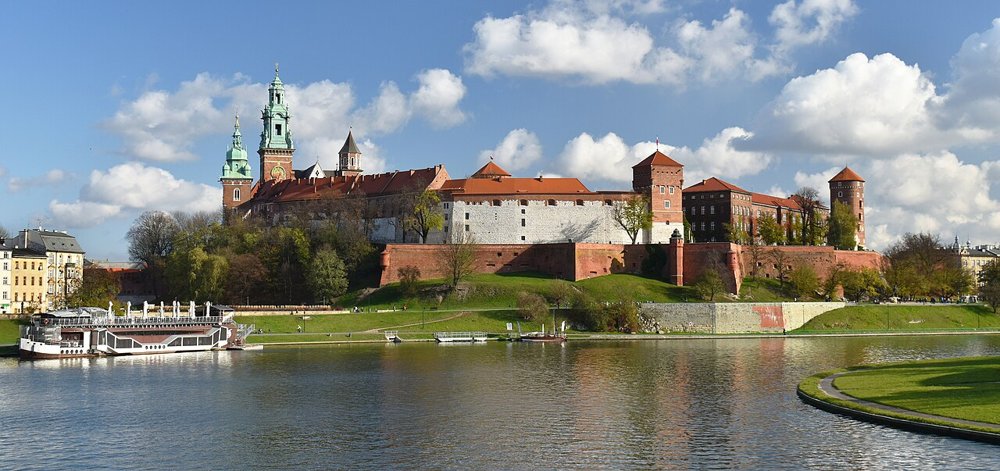
In 1979, excavators on Kanonicza Street in Kraków uncovered something that surprised even specialists: 4,212 iron bars shaped like small long-axes, together weighing over three and a half tonnes, buried in the second half of the 9th century. No text says who owned that iron. The label "Treasure of the Vistulans" is an attribution, and the Vistulans themselves leave only three thin traces in the written sources. From those traces, from hillforts and from a mound wrapped in legend, scholars have spent some 120 years building an early state on the upper Vistula. This article tests how much of it holds.
The Vistulans (Polish Wiślanie, Latin Uuislane) are usually described as the tribe of the Kraków region, that is Lesser Poland between the upper Vistula, the Dunajec and the foothills of the Carpathians. Open a handbook and you tend to find a territory, a main stronghold and a story of rise and fall. Go to the primary sources instead and you hold surprisingly little. There is an entry Uuislane in a 9th-century list of peoples, a country name in King Alfred's Old English Orosius, and a single scene in the Life of Methodius. That is everything written down about a people called "Vistula folk" before the year 1000.
This is no reason to drop the subject. It shows how history grows out of scraps. Beside the three passages stand finds that need no names: large hillforts, a huge iron hoard, a plaster basin beneath a church. Whether those finds belong to "the Vistulans" is interpretation. So this article keeps written sources, archaeology, later tradition and modern hypothesis apart as far as possible. Related cases are the neighbouring Polans, who later carried the Piast state, and the Moravians to the south.
The ethnonym, the name of a people, is transparent. Wiślanie are "the people on the Wisła", the Vistula. The river is far older than any Slavic people. Ancient geographers knew it: Pliny the Elder mentions a Vistula, Ptolemy a river called Ouistoulas. The name belongs to an older linguistic layer and is generally traced to an Indo-European root meaning "to flow"; the details are disputed among linguists.
What matters for our question lies elsewhere. A name like "Vistula folk" can be a genuine self-designation, but it can also come from outsiders who simply meant the people living along a river. Whether the inhabitants of the Kraków region called themselves that, we do not know. The name appears only in texts written by outsiders: in Bavaria, in England and in the circle of the Slavic mission.
In the late 9th century the Anglo-Saxon king Alfred had the late-antique world history of Orosius translated into Old English and expanded with a description of northern Europe. There, by the usual reading, the Wisle lond lies east of the land of the Moravians, and further east live the Dacians, who were once Goths. That is a country name, not a tribal report. Alfred's informants evidently knew the region only by hearsay, and the direction stays vague.
A second passage in the same work is more vivid: the merchant Wulfstan's account of his voyage from Hedeby to Truso, which took seven days and nights. He describes the Vistula as the boundary between two lands:
Sēo Wīsle is swīðe mycel ēa, and hīo tōlīð Wītland and Weonodland.
"The Vistula is a very large river, and it separates Witland and Weonodland."Alfred's Old English Orosius, Wulfstan's account (Germania chapter); wording in normalised spelling after the standard editions, English translation our own
The text goes on to say that Witland belongs to the Estonians (Old English Estum, the Aestii) and that the Vistula flows out of Weonodland into the Estmere, the Vistula Lagoon. Weonodland is the land of the Wends, that is of the Slavs. From Wulfstan's point of view the Slavic land begins where the Vistula comes from, in the south. Of Vistulans as a people he says nothing, but he does say that the river is both a trade route and a border. We return to that line at the end.
A third, smaller trace comes from the Old English poem Widsith, which has a phrase about the "Vistula wood" (Wistlawudu). The poem is hard to date and tells of wars among Goths; nothing links it to Slavs on the Vistula. We mention it for completeness only.
The oldest mention of the name hides in an unassuming text usually cited as the "Bavarian Geographer" (Descriptio civitatum et regionum ad septentrionalem plagam Danubii). It lists the peoples north of the Danube and east of the Frankish realm, each with a number of civitates, meaning fortified places or fortress districts. In the second list, between the Ungare and the Sleenzane (the Silesians), stands the entry Uuislane, also rendered Vuislane or Vislane in the literature. In the usual reading no number of strongholds follows the name. Its neighbours fare better: the Silesians receive 15 strongholds, the Lendizi 98, the Opolini 20 and the Glopeani 400 or more.
When the text was written is open. Proposals range from the 830s and 850s (Bernhard Bischoff) to the 870s (Aleksandr Nazarenko). Its author is unknown. That the entry refers to the Vistula people is the standard reading and phonetically obvious; it is not proven, because the text says neither where this group lived nor how large it was. It shows above all that someone at a Bavarian court or in church administration knew the name in the 9th century. That fits the trade routes down the Danube and the mission then getting under way in the south-east.
The most famous scene stands in chapter 11 of the Old Church Slavonic Life of Methodius (Vita Methodii). Methodius died in 885, and the text was written soon afterwards, but it survives only in manuscripts from the 12th century onwards. The chapter deals with the missionary's prophetic gifts. First the author cites a very powerful pagan prince who "sat on the Vistula", mocked Christians and did them violence. Methodius had a message sent to him (paraphrased here): it would be good for him to be baptised of his own free will in his own land, lest he be baptised against his will as a captive in a foreign land and then remember these words. And so it came to pass.
Two things stand out. First, the text gives no name and no place beyond the river. The manuscripts offer the location in forms that can be understood as "on the Vistula" or as "among the Vistula dwellers"; scholars discuss both. Second, the scene sits in a row: right after it come a prophecy for Svatopluk, ruler of the Great Moravian realm, and one about a nobleman with a dubious marriage. The author is not after politics but after proof that his saint could foresee the future.
The common narrative fills the gaps like this: the prince was the ruler of the Vistulans, his seat was Kraków or Wiślica, and the "foreign soil" means an intervention by Svatopluk, who subdued the Vistula lands in the 870s. The chain is plausible, but every link is interpretation. The Life reports only briefly that the prediction came true. Who captured the prince it does not say; by the usual translations neither Svatopluk's name nor a city is mentioned at this point, and a year is missing as well. Dates vary by author around the 870s. That Methodius had a message sent to the prince is in the text; whether he ever went to Lesser Poland himself is not.
Anyone who takes this seriously keeps two things: a Vistula prince was known in the Moravian world of the late 9th century, and Christianity stood at his door. The text gives no more. A "Great Moravian occupation" of Lesser Poland has not been found archaeologically, nor have early Christian cemeteries in the region.
Where written sources fall silent, spade and aerial photograph speak. In the Kraków region and along the Carpathian rim a dense landscape of hillforts arose from the 8th century and above all in the 9th. A gord (the Polish term) is a settlement enclosed by rampart and palisade, often on a rise or in a river bend. Polish summaries count roughly thirty sites in western Lesser Poland dated to the 9th century; the number depends strongly on the dating.
The best-known example is Stradów in Świętokrzyskie. The complex covered about 25 hectares and, by current assessment, existed from the 8th to the 12th century. Its core, the "Zamczysko", measured 1.5 hectares and was surrounded by a horseshoe-shaped rampart with a ditch. Excavators found traces of timber houses, ovens and fortifications. Towards the end of the 10th century the stronghold was taken, and its importance declined. Who took it is a matter of reading; the usual interpretation names the Polans. Kraków's Wawel, Wiślica and other places also show strongholds of this period in excavation.
The limit of the statement matters. That large strongholds existed is a finding. That they belonged to one state is a hypothesis, and that this state was "that of the Vistulans" is a label that researchers attached later. Archaeology identifies settlement and power centres, but not tribal borders.
Back to the 4,212 bars. They were found in 1979 during excavations on Kanonicza Street below the Wawel and are called grzywny in Polish scholarship. They are iron bars hammered flat at one end into a blade that imitates a small long-axe, with an eye at the other. Together they weigh about 3,630 kilograms. Radiocarbon dating confirms the archaeological estimate: the hoard was buried in the second half of the 9th century. Such bars circulated from around 800 until the middle of the 10th century.
Its significance lies in the distribution. Axes of this kind occur mainly in Moravia and western Slovakia, where they count as a mark of the Great Moravian period. Research today mostly sees them as a proto-currency, iron passed on as payment, gift or bride price before coins became usual in the region. The Kraków hoard is larger than everything known from Moravia and Slovakia put together, where only about 3,000 pieces have come to light. That makes Kraków the most striking find spot for a commodity whose core area lies further south.
What follows? The cautious statement is this: in the late 9th century Kraków was a place where enormous iron stocks gathered, and its people had contact with the economic forms of Great Moravia. Who hoarded the iron, a ruler, a merchant or the inhabitants of a stronghold, remains open. The name "Treasure of the Vistulans" is customary at the Archaeological Museum in Kraków, but the museum itself points out that the attribution cannot be proven.
Wiślica in the Nida valley, a good sixty kilometres north-east of Kraków, carries the people's name in its own. Around 1900 the historian Karol Potkański took the place for the capital of a Vistulan state bordering Great Moravia. Archaeologically there is a stronghold on a long-distance trade route, with beginnings dated to the late 9th and 10th centuries, plus a residence with two palaces and rotundas, later called the "Regia". The place first appears in a written source in 1079, in the New Świętokrzyska Chronicle.
The most intriguing find for our question dates from 1958. Beneath the foundations of a small church of the 10th or 11th century, workers came upon a basin made of gypsum. It is often interpreted as a font for mass baptisms in the 9th century and counts as one of the oldest Christian traces on Polish soil. Some have linked it to Methodius. That is the popular reading; as proof of a mission it does not hold. The basin is a finding; its baptismal purpose and any link to Methodius are interpretation, and no text or inscription confirms the use.
After the end of Great Moravia, around 900, the name of the Vistulans disappears from the sources. Not just the name: from the 10th century we have few voices about Lesser Poland at all. One of the first belongs to Ibrahim ibn Yaʿqūb, a Jewish merchant and diplomat from Tortosa in Muslim Spain, who travelled Central Europe around 965. His report does not survive in the original but was quoted in the 11th century by the geographer al-Bakrī. According to it, the realm of Boleslav of Prague extends from the city of Prague to the city of Kraków, a three-week journey. As trade goods he names slaves, tin and furs; Mieszko appears as a separate ruler in the north.
The usual reading: around the middle of the 10th century Kraków stood under Bohemian rule or at least Bohemian influence, and long-distance trade ran from Prague through Kraków onwards to the east, towards Rus. The interpretation hangs, however, on a single quotation transmitted through intermediate stages. Archaeologically Bohemian rule in Kraków is hard to grasp, and no source knows of an event that made the Vistulans part of Bohemia. For the history of the Bohemians, see our article on the Czechs.
Constantine Porphyrogenitus names a "White Croatia" in the north in the 10th century. Some scholars look for the White Croats in Lesser Poland or Silesia. That remains a hypothesis without firm support, and the Vistulans do not appear in Constantine's text.
When Kraków became Polish is unclear. The Dagome iudex of 991, preserved only in a summary made in a papal register in the 11th century, names Kraków (Craccoa) as a point on a boundary line running from "Rus" to the Oder. Some read this as proof that Mieszko I ruled as far as Kraków by about 990; others find the passage too unclear. The chronicler Cosmas of Prague reports around a hundred years later that a Piast ruler wrested Kraków from the Bohemians around 999. Both datings stand side by side. Only the result is secure: around the year 1000 Lesser Poland belongs to the domain of Bolesław I the Brave.
Church organisation is also secure. At the Gniezno meeting of the year 1000, three bishoprics were created under the new archbishopric of Gniezno: Kołobrzeg, Wrocław and Kraków, as Thietmar of Merseburg reports. For Kraków he names Bishop Poppo, probably a man from the Rhineland or Lotharingia. A Kraków catalogue of bishops from the 13th century lists two names before him, Prohor and Proculf. Some scholars take them for bishops of the Bohemian period; the see would then be older than 1000. This cannot be proved. According to tradition Poppo laid the foundation of the first Romanesque church, dedicated to Saint Wenceslas, from which today's Wawel Cathedral grew.
South of the Vistula, in the Podgórze district, rises Krakus Mound, an artificial hill about sixteen metres high; in the east of the city, near Mogiła in Nowa Huta, lies the smaller Wanda Mound. Tradition calls them the graves of the city's founder Krak and his daughter Wanda. These names come from chronicles that arose only around 1200, above all that of the Kraków bishop Wincenty Kadłubek. There Krak builds the city, and Wanda refuses the suit of a German prince and goes into the Vistula. As a source for the time around 880 this is worthless; it is a literary origin story that gave Kraków a glorious past. No source decides whether Krak existed.
What do the mounds themselves say? Krakus Mound was investigated from 1933 to 1937. The excavators found timber remains of a central construction, pottery, flint tools and a fitting of Avar type from the 8th century; they found no grave. The mound is usually placed in the 7th or 8th century, but not exactly fixed. The investigations at Wanda Mound in 1913 and in the 1960s produced no clear result on age or purpose. Written evidence for Wanda Mound begins only in the 13th century, in the circle of Mogiła Abbey, founded in 1225. For both mounds the early period remains dark; they connect to the Vistulans as a people only through conjecture.
Now and then one reads that the mounds were part of a Celtic calendar or an astronomical installation because timber posts seem aligned with solstice points. That is a modern interpretation that cannot be proved, and it has no bearing on the 9th century.
The picture of a "state of the Vistulans" is younger than the sources. In the late 19th and early 20th century Polish historical scholarship wanted to know what had come before the Piasts, and found an answer in the fragments: Karol Potkański combined the Geographer's entry, the Methodius Life and hillfort finds into a powerful principality around Kraków and Wiślica reaching to the Carpathians. Later authors added borders and an area of about 7,000 square kilometres. The idea that a Svatopluk destroyed this state in the 870s belongs to it as well.
The critical counter-argument runs like this: we do not know whether all those strongholds belonged to one rule. We do not know whether the people of the region saw themselves as one group. And we do not know what the 9th century looked like in the settlements, because traces of Great Moravian occupation are missing, as are early Christian graves. Defenders of the model point out that the size of the strongholds and the iron hoard suggest a strong central power. Both positions appear in the literature, and both are interpretation.
Here lies the appeal of the subject. The Vistulans are less a people we observe than a thought model that scholars have stretched over a thin fabric of sources. One can work well with it as long as the seam between evidence and hypothesis stays visible.
That leaves the river. Wulfstan describes the Vistula as a great stream running from the land of the Wends into the Vistula Lagoon; ships and merchants between Kraków and the coast no source can describe. At its lower end, on the lagoon, lay Truso, a trading place of the 8th to 10th centuries from which amber, furs and slaves were traded. Excavations there found scales, weights, Scandinavian jewellery and traces of amber working. A burnt layer suggests that the settlement ended violently around the year 1000.
Whether an unbroken trade chain ran between the strongholds of Lesser Poland and Truso is not proven. On the map it lies close. The written sources connect the two regions only indirectly: Alfred's text speaks of the Vistula as a border, Ibrahim ibn Yaʿqūb of Kraków as a trading place on a route towards the east. For readers who want to follow the river further, our articles on amber and on the Vikings on the Baltic are good places to go. Those looking east will find in the article on the Vikings in the east and on Kyivan Rus the other end of the trade routes. West of the Vistula mouth lived the Pomeranians.
The Vistulans are a good example of the limits of early history. Three passages reveal a name, a country and a scene at the edge of the Methodian mission. The finds add large strongholds, an iron hoard and a basin beneath a church. Everything beyond that, whether princes, state borders or a sense of belonging, is inferred. The Piasts took over the land around 1000, the Bohemians had influence before them, and the Moravians shaped the time before that. About the people themselves, their language, their gods and their graves, we know almost nothing, and that is exactly what can honestly be stated.
The Polans · The Moravians · The Czechs & Bohemians · Amber – the gold of the North · Vikings on the Baltic · The Pomeranians · The White Croats · The Rus (Kiev).
All History & Finds articles →
A river, a handful of chronicle lines, and a name that has outlived its tribe by more than a thousand years: the story …
Read more →