In the late 10th century an island in the middle of Opole carried a stronghold with a timber-and-earth rampart, and its soil held so many wooden toy boats that archaeologists speak of about a hundred. The name of the people who lived in the area earlier appears in a single line of a 9th-century register: Opolini civitates XX, the Opolans have twenty strongholds. There is no further written evidence for them before the year 1000. This article separates what the list says, what the spade shows and what scholars have assembled from both into a tribe.
The Opolans (Polish Opolanie, Latin Opolini) are counted among the tribes of Silesia, more precisely of the upper Oder region around present-day Opole (German Oppeln). Open a handbook and you usually find a tribe with a main stronghold, a cult mountain and a chronicle of conquests by Moravia, Bohemia and Poland. Ask for the sources and the answer is sober: the name survives in exactly one 9th-century text, the so-called Bavarian Geographer, where it stands in an enumeration of peoples with numbers of strongholds. That is the entire written record before the year 1000.
Beside it lies a rich archaeological record that needs no names. It concerns above all the stronghold on Ostrówek, an island in the Oder whose large rampart is dated to the second half of the 10th century, a good hundred years after the list. Reading both together is tempting and common in scholarship; one should only see where the link is made. Similarly thinly documented are the neighbouring Vistulans on the upper Vistula, who stand in the same register, and the Silings, whose name is tied to Mount Ślęża. A better-attested neighbour is the case of the Polans, who later carried the Piast state.
The source itself writes Opolini; "Opolans" is the English rendering of Polish Opolanie. Both mean the same group, the people of Opole. The word opole denotes, in the West Slavic languages, a form of territorial self-government, an association of neighbouring settlements. The city's name was therefore not first a proper name but an administrative term. Whether the Opolini of the list called themselves that, or whether the name comes from outsiders who labelled a region with their own term of order, cannot be decided.
A confusion lurks between words. Today the inhabitants of the city are also called Opolanie in Polish, and in German Oppelner. That is not what the early medieval tribe means; what bound people together in the 9th century we do not know, and a sense of tribal identity cannot be read from the list. The ending -ini is likewise the Latin rendering of a Slavic name by a scribe who heard or copied it. That it refers to the people of a place called Opole is the most obvious reading and standard in scholarship; the text does not prove it.
The source carries the makeshift title Descriptio civitatum et regionum ad septentrionalem plagam Danubii, "Description of the strongholds and lands north of the Danube". The manuscript was discovered in 1772; the usual name "Bavarian Geographer" goes back to the Polish scholar Jan Potocki, who introduced it in 1796. The text is short and consists essentially of lists: first peoples close to the Frankish realm, then, in a second and far larger list, the peoples living further east, each with a number of civitates.
Who wrote it and when is open. Bernhard Bischoff took a monk of Reichenau Abbey to be the author and dated the work to the 830s to 850s; Aleksandr Nazarenko thinks the 870s more probable. The purpose is also a matter of interpretation: a compilation for the East Frankish court or for church administration, perhaps in connection with mission and embassies, is the usual guess. What matters is that the text looks at the Slavs from outside. The informants, perhaps travellers, envoys or merchants, are unknown.
In the second list the names of Poland's southern neighbours follow in dense sequence. After the entry Uuislane, for which no number is transmitted, come the Sleenzane with 15, the Lunsizi with 30, the Dadosesani with 20, the Milzane with 30, the Besunzane with 2, the Uerizane with 10, the Fraganeo with 40 and the Lupiglaa with 30 civitates. Then come the Opolini and the Golensizi with 5. The sequence is a fact about the text; whether it mirrors a map is again interpretation.
Lupiglaa civitates XXX. Opolini civitates XX.
"The Lupiglaa: thirty strongholds. The Opolini: twenty strongholds."Bavarian Geographer (Descriptio civitatum et regionum ad septentrionalem plagam Danubii), second list of peoples; Latin wording after the standard editions (public domain), English rendering our own translation
The word civitates is usually translated "strongholds" or "fortified districts" in the literature. The Latin term originally means a community or a town; for the scribe they were evidently fortified places, perhaps also the administrative districts around them. What criteria he applied he does not say. Overview accounts count Opole and Toszek (Tost) among the twenty strongholds of the Opolans. That attribution is a modern identification; the text names not a single place.
Twenty strongholds is a middling figure by comparison. The list gives the Lendians 98, the Glopeani more than 400, the Sleenzane 15. The numbers have long tempted researchers because population figures can be derived from them. Popular texts give estimates of thirty to forty thousand people for the Opolans. Such values come from assuming a number of inhabitants per stronghold; they are calculations built on assumptions, not findings.
There are three reasons for caution. First, nobody knows how the scribe counted. Second, numbers in medieval copies are prone to error, and Roman numerals blur easily. Third, between the record and the strongholds that archaeologists later excavate lies a period in which strongholds were founded and abandoned. How many of the twenty can be assigned archaeologically to the 9th century depends on dating that is often coarse; we know of no reliable overall count. More on the fortified landscape in general is in the article on castle studies.
The sequence reads like a walk through Silesia and Lusatia, and some names can be tied to later landscapes. The Sleenzane are taken to be the Ślężanie, the people around the Ślęza river and Mount Ślęża (Zobten); how far the name is connected with the ancient Silings is discussed in the article on the Silings and remains disputed. The Dadosesani are equated with the Dziadoszanie around Głogów, the Golensizi with a group in the area of Racibórz, Cieszyn and Opava. The Lupiglaa call to mind the Głubczyce plateau. None of these equations is certain; they rest on similarity of names, on position and on the wish to fill the list with landscapes.
The Milzane stand for the Milceni in Upper Lusatia, a people counted among the ancestors of the Sorbs. It is a trait of the list that it names Silesians, Lusatians and Poles in one breath without saying who is subject to whom. The Opolans appear as one unit among several, not as part of a larger association. That does not mean political unity: the text says nothing about rulers, alliances or a common leader.
In popular texts the entry often comes with the year 845, and some pages claim the Opolans were "first mentioned in 845". That is a simplification. The text is undated; scholarship oscillates between the 830s and 870s, and 845 is only one point within that span. Equally misleading is the claim that Opole itself is mentioned in the 9th century. The source names a people who, in our reading, lived around Opole, but no place. The town appears as a name only later in charters; the literature names an early instance for 1198, when Bishop Jarosław calls himself "lord of Opole" (dominus de Opol).
The area assigned to the Opolans lies in the south of present-day Poland, in the region later called Upper Silesia. The Oder, still a medium-sized river here, forms with its arms and oxbows a landscape of floodplains and terraces. To the south it opens towards the Moravian Gate, the depression through which trade routes ran from the Danube to the Baltic since prehistory, and the Amber Road is occasionally linked with it (more in the article on amber). That the Opolans deliberately oriented their land to this traffic position is an assumption found in the literature, without a text to support it.
The borders of the tribal territory are unknown. Maps in school books draw lines derived from later administrative borders of stronghold districts and castellanies. That is a back-projection resting on the assumption that early territorial divisions survived in later ones. Whether this is true has been debated for a long time.
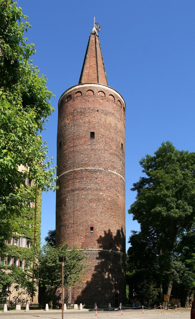
For scholarship, the heart of the Opolan land lies on Ostrówek, literally "little island". It is a river island between the Oder and the Młynówka mill race, in the centre of the present city. Today the Piast Tower stands here; beneath it, partly under car parks and the grounds of the National Centre of Polish Song, lies the early medieval stronghold.
On the prehistory of the site, local accounts report that the island was already used in the late Roman period and that iron was smelted from bog ore at the time. The oldest Slavic traces of settlement are placed in the 8th and 9th centuries by the same accounts, that is, in the period the list comes from. That fits the date of the Opolan entry in time but does not prove that this very settlement is meant by one of the Geographer's civitates. A stronghold in the sense of the later rampart is, according to the overviews we have, not yet demonstrated for that period. Whoever calls the island "the main stronghold of the Opolans in the 9th century" is formulating a hypothesis.
The finding for the stronghold of the late 10th century is secure. According to the accounts we consulted, a timber-and-earth rampart surrounded the island; the stronghold covered about three quarters of a hectare, the rampart measured about 280 metres in circumference. An estimated one to two hundred people lived on this area, including a few dozen warrior families. The number of inhabitants is again a calculation from area and assumptions. The decade between 977 and 995 is given as the founding period; the city of Opole itself names the year 985 on its website and refers to radiocarbon measurements of charred timbers.
For a stronghold of this size the finds are exceptionally numerous, and the damp soil has preserved organic material. The archaeologist Sławomir Moździoch reported in an interview with the local press about 7,000 pottery sherds, dozens of iron objects, some 2,000 animal bones and about 100 toy boats, a quantity not found in other early Piast strongholds. In addition there are wooden vessels, jewellery, tools, weapons, riding equipment, remains of clothing, shoes with embroidery, bronze ornaments and small crosses. Such boats, if they really were toys, give an insight into everyday life, not into seafaring. The city of Opole itself points out that the boats suggest contacts with traders, not Viking settlers. The claim that Ostrówek was a "Viking fortress" therefore belongs among the misunderstandings.
Moździoch places Opole in comparison: the stronghold reached only about a tenth of the size of the Wrocław stronghold and a fifth of Bytom Odrzański. An oak rampart at more than four and a half metres depth, he says, was dated by dendrochronology to 1080 and shows that the complex was extended about a hundred years after its foundation and was larger than previously thought. We report these statements as given by the local press; we have not seen the scientific publication.
The history of research is itself a piece of the history of science. First finds were documented between 1930 and 1933 but, as a local newspaper reports, were not recognised as a Slavic stronghold by German researchers because of ideological reservations. Between 1948 and 1997 systematic excavations followed with interruptions and showed that the stronghold was built in the manner of other Piast strongholds. Since 2024 there have been plans to uncover and present parts of it; in April 2025 drillings led by Magdalena Przysiężna-Pizarska and Grzegorz Kusza of the University of Opole struck wood remains at 5.7 metres depth, interpreted as the edge of the fortification, and a silt layer at 4.7 metres marking the edge of the stronghold. The analysis of the soil samples was still pending when the reports appeared.
Why only drillings and small trenches are possible in a city is simple: Ostrówek is built over. The stronghold is therefore not fully investigated. The finding rests on sections, and new drillings are already shifting the assumed extent.
Here lies the core of the problem. The Geographer reports the Opolini in the 9th century. The excavated rampart dates from the second half of the 10th century, and, on the usual interpretation, from the time when the Piasts took possession of Silesia. Between the two lie at least a hundred years in which rule, trade routes and settlements may have changed. The large stronghold is therefore no testimony of the "Opolans" in the sense of the list but of early Piast territorial rule in an area where Opolans are said to have lived earlier.
This is no quibble. Archaeology recognises centres and building methods but not tribes: it can show that the stronghold was built on the pattern of Piast strongholds, not that descendants of the people of the list sat in it. That an older settlement lay on the same spot is assumed but only weakly supported by the finds so far. It makes sense to treat the Opolans as a name from a written source and Ostrówek as an archaeological place, and to label the connection a working hypothesis.
Geographically the Opolan land lies closest to the Moravian Gate, and so the question whether Opole stood under Moravian influence in the 9th century is a classic of scholarship. English-language overviews state that Great Moravia conquered the territories of the Opolans in the year 875. We could not identify a source passage supporting this year. The model behind it is an inference from the general situation: Svatopluk, ruler of the Great Moravian Empire from the 870s to the 890s, is said to have extended his power northwards. The only scene cited for it is the Vistula prince episode of the Life of Methodius, discussed in the article on the Vistulans; Opole is not mentioned there.
Anyone wishing to test the model needs finds. A Great Moravian presence in Upper Silesia, for instance through strongholds in a Moravian building style, churches or graves with Great Moravian goods, is not known to us. That does not rule out contacts, since trade and exchange need no occupation. One can record as fact only that the south of the Opolan region lies close to Moravia. Everything else, a "tribute" or a "conquest", is interpretation. On the realm that bordered the Opolini to the south, see the article on the Moravians.
With the collapse of Great Moravia around 900 the trace also vanishes from the sources. Then the Bohemia of the Přemyslids comes more strongly to the fore, and the attention of scholarship turns to it. Overview accounts assume a Bohemian phase of Silesia around the middle of the 10th century, carried by Boleslaus I, who reached far to the east after the battle of the Lechfeld in 955; the accounts say he occupied Kraków and thereby controlled the trade routes from Prague to Kyiv. Two hints support this: the report of Ibrahim ibn Yaʿqūb of about 965, according to which Boleslaus's land reaches from Prague to Kraków (see Vistulans), and coin finds. Specialists note that the oldest Bohemian coins of the late 960s and early 970s were found not in Prague but near Wrocław. That is a hint of Bohemian reach in the upper Oder area, not a statement about Opole.
More on the Bohemians and their history is in the article on the Czechs and Bohemians. What matters for our question: a Bohemian administrator in Opole or a Bohemian stronghold on Ostrówek is proven neither in the sources nor, as far as we know, in the excavations. That Opole "belonged to Bohemia", as some maps show, is a reconstruction from indications that rest on Wrocław and Kraków.
In 965 Mieszko I married Dobrawa, a Bohemian princess, and thereby tied his land to Prague. After Dobrawa's death in 977 relations worsened; for 990 Thietmar of Merseburg records a war between Mieszko and the Bohemians without naming the causes. The result of the war is usually taken to be that Silesia fell to Poland; scholars even suspect that the dispute concerned above all Silesia and not Lesser Poland. This fits the archaeological hints that Mieszko controlled parts of Silesia as early as the mid-980s, for the large Piast strongholds in Wrocław, Opole and Głogów arose then.
Marcin Danielewski, who has studied the strongholds of the Piast realm, describes that a first fortified settlement existed in Wrocław in the first half of the 10th century and a new structure arose in the 980s; Mieszko took over Silesia, built new strongholds or remodelled existing ones and, in this region, abandoned the notorious practice of burning captured strongholds. Moździoch dates Opole to 983: at that time, when the Slavs east of the Elbe rose against the Empire (compare the Lutici), Mieszko is said to have built strongholds along the Oder. Both are assessments belonging to individual researchers. What is secure is the finding that in the last quarter of the 10th century a large stronghold stood on Ostrówek. Who built it, a retainer, a governor or Mieszko himself, no text says.
The ground becomes firmer with the year 1000. At the Congress of Gniezno, according to Thietmar of Merseburg, the diocese of Wrocław arose among others under the archbishopric of Gniezno, and it also covered the area around Opole. The land of the former Opolini thereby belonged ecclesiastically to a diocese centred on the Oder and politically to the realm of Bolesław I the Brave. The word "Opolans" has vanished from the sources after that. The people remained, and some stronghold districts may have continued under new names, which can only be conjectured.
The great chronicles of the 12th century are of little help for our question. Cosmas of Prague wrote his Bohemian history until his death in 1125, and Gallus Anonymus composed the first chronicle of the Polish rulers in the early 12th century. Both tell of wars and territorial disputes between Bohemia and Poland, and both are considerably younger than the events of the 10th century they report. In the accounts we have evaluated, the Opolans as a people are named by neither. We therefore cannot draw on them to prove Bohemian or Polish claims to Opole, and for this period must rely on Thietmar and archaeology.
The period of Poland's fragmentation gives Opole a new role. After the division of Silesia among the sons of Władysław II in 1163, Opole becomes traceable as a duchy of its own from 1172/73. In 1198 Bishop Jarosław calls himself "lord of Opole" (dominus de Opol); in 1201 the land fell to Mieszko I Tanglefoot, who united it with Racibórz in 1202. His son Casimir I succeeded in 1211, according to the available accounts moved the settlement from Ostrówek to the right bank of the Oder and founded a town in the years around 1217; German town law follows in 1254 by the usual account. On the island the building of a masonry castle began about 1228, its main building completed about 1260.
For our subject it matters that the tribe no longer plays a role by this time. What the early strongholds meant for the later dukes Moździoch puts in the remark that places Mieszko chose as seats of regional power mostly remain local administrative centres to this day. That holds for Opole: the city remained the centre of the region, first as ducal seat, then as an administrative town.
The Piast Tower, the only surviving piece of the old complex, is often connected with the time of Mieszko. That is an error. The tower is a masonry round tower and arose in the late 13th or early 14th century under the Silesian Piasts; the castle chapel was consecrated in 1307. It has nothing to do with the timber-and-earth rampart of the 10th century, even though it stands on the spot where that stronghold lay. The name refers to the dynasty.
In 1327 the duchy came under Bohemian suzerainty; in 1532 John II the Good, the last Piast of Opole, died, and the land passed to the Habsburgs. From 1645 to 1666 it was held in pledge by the Polish Vasas. In 1742 Prussia took the region. Between 1928 and 1931 the castle was demolished except for the tower to make room for an administrative building. Today the tower is about 42 metres high with 163 steps; Opole itself is the capital of the voivodeship and known as the city of Polish song.
The Opolans are a case in which a line, an island and a series of interpretations together yield a picture that looks sharper than it is. The line says that in the 9th century someone in the West knew a people called Opolini and credited them with twenty strongholds. The island shows that in the late 10th century a stronghold stood there that was part of the Piast build-up on the Oder. Everything in between, tribal territory, cult mountain, Moravian overlordship, Bohemian administration, is inferred. Whoever tells the history of Opole therefore has two firm points and a gap of more than a hundred years.
That is precisely what makes the case useful for reading early medieval ethnonyms generally. As with the Vistulans and the Silings, a name in a list is a beginning, not a people. The strongholds and finds show that in the Opole land people settled, traded and exercised power. What they called themselves, what they believed and how they chose their rulers remains open.
The Vistulans · The Silingi · The Polans · The Moravians · The Czechs & Bohemians · The Milceni · The Sorbs · The Liutizi.
All History & Finds articles →
For three centuries Orkney was ruled by earls who served two kings and fully obeyed neither. They fought in Ireland, in …
Read more →Before the Vikings, Ireland had no towns. It had monasteries, royal seats and ringforts, but no place where thousands …
Read more →