 Between the eastern Carpathians and the Black Sea coast, in the ninth and tenth centuries, lived a Slavic grouping about which the written sources spare barely three dozen words: the Tivertsi. They sat along the Dniester, were apparently numerous, held fortified places, and marched with Kyivan princes on Constantinople. Then they vanish from the chronicles, while workshops, weights and silver coins still lie in the ground. Few East Slavic groupings show so clearly how thin our foundation is, and how much later centuries have read into it. Here is what is documented, what remains plausible, and what is pure interpretation.
Anyone who pictures early Rus as a solid block has miscounted. On the south-western rim of that world, where the Dniester runs out of the wooded hills of Podolia into open steppe, sat a grouping the Kyivan chroniclers call Tivertsi – East Slavic Tiverci, Ukrainian Tyverci.
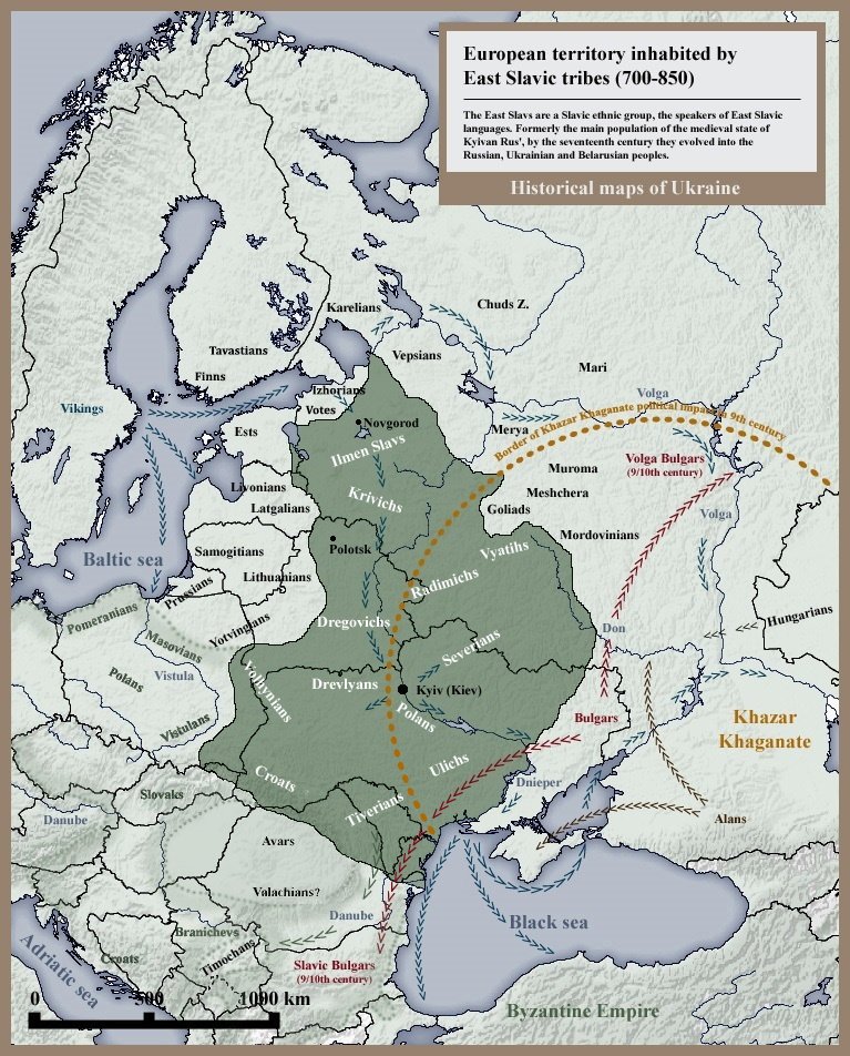
Their territory, as scholarship currently reconstructs it, covered the middle and lower Dniester: western Ukraine, large parts of today's Republic of Moldova, perhaps strips of eastern Romania and the southern Odesa region. This was borderland in the literal sense: forest-steppe to the north, a nomad corridor to the south, Byzantium and the Danube to the west.
That is what makes them interesting. Slavic farmers, Scandinavian long-distance traders, a Romance-speaking population, Bulgarian rule and steppe horsemen all met here in a narrow space. And for exactly that reason, almost nothing here is unambiguous.
Practically everything written about the Tivertsi sits in the Povest vremennykh let, the so-called Primary or Nestor Chronicle. The text describes the ninth and tenth centuries, but survives only in far later manuscripts: the Laurentian Codex of 1377, the Hypatian Codex of around 1425.
Between the events described and the oldest surviving copy lie a good four hundred years; between the events and the presumed redaction in Kyiv, still around two hundred and fifty. The chronicle's early dates – 885, 907, 944 – are not minuted records but retrospectively calculated, conventional placements.
Then there is the tendency. The chronicle was edited in Kyiv, in the interest of a dynasty that wanted to justify its rule over the southern groupings. Whoever reads it always reads a justification along with it.
The decisive passage is a geographical note in the catalogue of peoples at the start of the text. It assigns Tivertsi and Ulichs to the Dniester and expressly claims that their towns still stood in the writer's own day.
And the Ulichs and the Tivertsi sat along the Dniester and reached as far as the Danube. There was a multitude of them; for they sat along the Dniester down to the sea, and their towns stand to this day.
Povest vremennykh let (Primary Chronicle), catalogue of peoples; Old East Slavic wording after the Laurentian version, our own translation
The textual history of this line matters. The Hypatian Codex offers a variant in which the Dnieper stands in place of the Dniester and the Southern Bug is named as well. Whether this is a scribal slip or an older tradition has never been settled, and with it the question of how far east the grouping actually extended.
The rest is quickly told. Later chronicle compilations link the Tivertsi to Askold and Dir and to fighting against Oleg. In 907 they appear in Oleg's army before Constantinople, in 944 in Igor's expedition – and that is the last mention of them anywhere.
For the campaign of 907 the chronicler adds a gloss: the Tivertsi are tolkoviny. More has been written about this one word than about everything else we know of this grouping.
The common reading derives it from Old East Slavic tŭlkŭ, "interpreter": people from a contact zone who spoke two languages and were therefore useful on campaign – possibly speakers of Greek on the road to Byzantium. This reading has largely prevailed since it was re-examined on linguistic grounds.
It is not the only one. The word appears a second time in the Tale of Igor's Campaign, there for foreigners, evidently meaning Cumans. Aleksey Sobolevsky concluded from this in 1910 that the Tivertsi were themselves a Turkic-speaking grouping subject to Rus. That thesis is now regarded as superseded, but it shows how soft the ground is: a single unclear noun carries an entire ethnicity.
The best-argued explanation of the name is also the least spectacular. In antiquity the Dniester was called Tyras – in Herodotus, later in Strabo, Pliny and Ptolemy. The river name itself is held to be Iranian, from a root meaning "swift". Tivertsi would then simply be "the people of the Tyras", Dniester-dwellers.
The timeframe fits. In Jordanes, writing in the mid-sixth century, the river is already Danaster; the old name Tyras was going out of use. A grouping name derived from it would therefore have to be older than the sixth century – a strong argument, but a reconstruction rather than a proof. Competing explanations, such as a derivation from the late antique fortress of Turris or from Turkic, have remained minority positions.
One side-observation supports the river reading indirectly: place names such as Tyvriv on the Southern Bug are connected with the grouping's name. The claim that Kamianets-Podilskyi was their "capital", by contrast, is pure conjecture with no archaeological basis.
A second and much older source is regularly brought in when the size of these groupings comes up: the so-called Bavarian Geographer, a ninth-century Latin list of peoples and settlement numbers. It names the Unlizi as a "numerous people" with a three-figure count of civitates, usually equated with the Ulichs. For the Tivertsi themselves there is no secure entry; proposals to find them behind names such as Stadici or Attorozi are hypotheses resting on etymology and neighbourhood logic.
The numbers are barely usable as statistics in any case. In such lists civitas means a fortified place with its hinterland rather than a town in the later sense, and the figures vary between manuscripts. Calculating population sizes from them means calculating with fog.
The relationship with Kyivan Rus was plainly not a voluntary partnership. Several chronicle versions report that Oleg waged war on the Tivertsi and Ulichs; scholars generally read this as meaning that a lasting subjugation failed at first.
After that they appear twice as a contingent – in 907 under Oleg, in 944 under Igor. Both are campaigns against Byzantium, both described in the chronicle as vast levies whose numbers nobody can check. Whether the Tivertsi marched as allies, as tributaries or as hired auxiliaries, the text does not say.
The pattern is familiar from other groupings: first war, then tribute, then integration into the levy. With the Drevlians the process is told at length, because it ended in catastrophe; with the Polans around Kyiv it is missing entirely, because the chronicle treats them as the core of Rus. The Tivertsi get two marginal notes.
The most famous siege in this region strictly concerns the neighbours. The Novgorod First Chronicle of the younger recension reports, under the year 940, that a town called Peresechen refused to submit; the commander Sveneld sat before it for three years and took it only with difficulty. Afterwards the tribute of the Ulichs flowed to him.
Sveneld is one of the more tangible figures of these decades: a leader with a Scandinavian name who serves under Igor and Sviatoslav, becomes fabulously rich, and turns up at the edge of nearly every crisis in the chronicle. His rise begins precisely here, on the south-western frontier.
Where Peresechen lay, nobody knows. The obvious equation with the modern village of Peresecina near Orhei is regarded in scholarship as uncertain at best. And a three-year siege by a tenth-century army is logistically so demanding that the figure is better read as narrative emphasis than as a war diary.
Archaeologically the region falls within the Luka-Raikovets culture (also Luka-Raikovetskaya), an early medieval culture running from the end of the seventh into the first half of the tenth century. It develops out of the older Prague-Korchak culture and spreads through the forest-steppe west of the Dnieper, with outliers towards the upper Tisza and the lower Danube.
Typical are settlement clusters of sunken-floor and ground-level houses with stone ovens, and from the eighth century onwards a marked increase in fortified places: timber-and-earth ramparts with ditches, often set on spurs above the river. The pottery shifts over time from handmade to wheel-thrown – a usable dating anchor.
The attribution of these sites to "the Tivertsi", however, is made by map, not by finds. No specific traits distinguishing them from their neighbours have been isolated. What we have is a region, not an archaeologically graspable people.
On the middle Dniester, in today's Rezina district of the Republic of Moldova, lie two of the key sites: the hillforts of Echimăuți and Alcedar, supplemented by places such as Rudi. Echimăuți was investigated in several campaigns between 1950 and 1964 and dated to the ninth and tenth centuries.
What came to light there is, for anyone interested in craft, the most exciting part of the whole story: smithies, weapon production and jewellery workshops inside the fortification, along with iron agricultural tools. This was no mere refuge, but a production site with specialised craftsmen.
Add trade. Weights of the ninth to eleventh centuries have been published from Echimăuți and Alcedar, and from Alcedar a hoard with silver coins placed in the late tenth century. Objects of Scandinavian type, including battle axes, are known from the region as well. Anyone using scales and weights is weighing out silver – we are in the same economic system as on the Varangian route.
At Alcedar a barrow cemetery of thirty-four low mounds was recorded; eleven were investigated in the early 1960s. Each mound contained several cremation burials, sometimes ten, sometimes well over forty – evidently the burial places of individual family groups across generations.
Cremation took place elsewhere; the burnt bone was then deposited on a clay surface within the mound, in shallow pits, or in urns. The grave goods are strikingly poor: a few glass beads, a neck ring, a handful of bronze pieces, iron knives. None of it is regionally distinctive; all of it belongs to general Slavic types.
At Brănești in the Orhei district lies a flat cemetery in which the transition is visible: a few early cremations, then some ninety-four excavated inhumations, the dead extended on their backs, heads to the west. The material runs into the first half of the eleventh century.
Massive earthen ramparts run through the landscape between the Prut and the Dniester, known in popular usage and older literature as "Trajan's Walls". They are impressive, and popular accounts like to attribute them to the Tivertsi. There is no basis for that.
Scholarship dates the Bessarabian ramparts predominantly to late antiquity or the migration period, with Gothic or late Roman contexts under discussion. The name Trajan is a late, probably modern attribution, not an ancient designation.
These must be kept separate from the "Serpent's Walls" in the Dnieper region near Kyiv. Their dating is disputed too: older excavations placed them in the late tenth and eleventh centuries and read them as defences against Pechenegs and Cumans, while newer radiocarbon dates argue for considerable time depth and several building phases. Two different systems, two different debates – and neither is a Tivertsi rampart.
Why was so much silver in the ground there at all? Because the Dniester was a route. Alongside the famous Dnieper road ran a second connection from the Carpathian foreland to the western Black Sea coast – less spectacular, but without the notorious rapids.
Anyone using it moved between Scandinavian long-distance traders, Slavic fort-holders, Bulgarian rule on the lower Danube and Byzantine markets. That Tivertsi were wanted as language-users in an army heading for Constantinople makes plain sense in such a landscape.
How this world looked from outside is shown by the Arabic descriptions of the Rus on the Volga – an eyewitness account we have examined more closely in the case of Ibn Fadlan. For the Dniester, a comparable eyewitness source is missing entirely.
In 915 the Pechenegs appear in the north Pontic steppes, a few years later on the lower Danube. Slavic settlements in the lower Dniester break off; in the south of the Prut–Dniester interfluve a Bulgarian-influenced culture prevails for a time.
The real collapse comes later. Many investigated settlements in today's Republic of Moldova end in the eleventh or early twelfth century – after the fall of the First Bulgarian Empire and under pressure from the advancing Cumans. The result is not a massacre but a drain: the population moves north.
It moved to where protection was available: into the orbit of the principality of Halych, which in the twelfth century gathered the lands between the Carpathians and the Dniester as far south as the Danube, with fort-towns such as Ushytsia and Bakota on the river. Older scholarship, Lubor Niederle among others, additionally assumed a move into the Carpathians and Transcarpathia; that remains a hypothesis. Only islands of Slavic population stayed in the Prut–Dniester region, and over time they were Romanised.
A grouping that disappears from the sources makes a convenient vessel. Ukrainian accounts see the Tivertsi as one building block of Ukrainian ethnogenesis, specifically for Podolia. Romanian and Moldovan researchers stress instead the mixed Romance-Slavic character of the Dniester population. Soviet works, in turn, filed everything into an all-East-Slavic scheme.
All three positions can be contested or supported with the same thin material, because the material does not answer the question at all. A cemetery tells you how people buried their dead, not which language was spoken at the graveside.
The modest finding is the honest one. In the ninth and tenth centuries a farming and craft-working population lived on the Dniester, with fortified places, long-distance trade contacts and changing overlords. Scribes in Kyiv called them Tivertsi. We know no more than that – and it is still a great deal.

The Rus (Kiev) · The Polans · The Drevlians · The Varangian route · The Dregovichi.
All History & Finds articles →
Sometimes a whole world of gods sits on a thumb-sized piece of bronze. The four Torslunda dies from the island of Öland …
Read more →From above they look as if drawn with a compass: perfectly circular ramparts, divided into exact quarters, with four …
Read more →