There is hardly any text about the Dobunni and a great deal of ground: a single narrative passage in Cassius Dio, an entry in Ptolemy, a good half-dozen names on gold coins and large earthworks in the Cotswolds. Even the tribal name stands in Dio differently from the way we write it. This article goes through what can be documented about the Celts of Gloucestershire, what remains interpretation, and which familiar claims, such as that of the “Dobunnic horse” at Uffington, do not hold up.
The Dobunni (Latin Dobunni) were a Celtic tribe in south-west Britain. A tribe here means a community with its own name and territory, not a state with fixed borders. Their heartland lay in the Cotswolds, the limestone upland of present-day Gloucestershire, and in the lower Severn valley. According to the usual account the area ran roughly from Bristol across Gloucestershire into northern Somerset and at times reached into Herefordshire, Oxfordshire, Wiltshire, Worcestershire and Warwickshire. That is a rough map, not a boundary; where a tribe ended, neither texts nor finds tell us for certain. The Cornovii and the Corieltauvi are named as neighbours to the north, the Catuvellauni to the east, the Atrebates and the Belgae to the south, the Silures and the Ordovices to the west. These neighbourhoods are also partly inferred.
The record is thin. A short narrative in Cassius Dio about the year AD 43, a line in Ptolemy from the middle of the second century, a few inscriptions from Roman times: that is all that authors and stonecutters say about the tribe. As far as we could check, Tacitus, who otherwise describes the conquest of Britain at length, never names the Dobunni, though we did not read all his works through. Most of what we know therefore comes from the ground: coins with names on them, huge earthworks at Bagendon, a fortified enclosure near Bourton-on-the-Water, later the ruins of the Roman town of Cirencester. Writing about the Dobunni is to a large extent writing about archaeology and numismatics, the study of coins, and one has to keep saying where a sentence rests on a text and where on an interpretation.
Our articles on the Britons and on the Celts as a whole give an overview of the island's people before Roman times. This one is about a single tribe and about how sturdy each statement about it is.
The name has two faces. In maps and handbooks it reads Dobunni. That is how it stands in Ptolemy, whose Geography dates to about AD 150; in the English edition at Thayer's site it appears as “Dobuni”. Cassius Dio, on the other hand, writing a little over a century later, calls them the “Bodunni” in his account of Claudius's campaign (60, 20). In Earnest Cary's English translation (Loeb Classical Library) the passage says that Plautius gained “a part of the Bodunni, who were ruled by a tribe of the Catuellani” by capitulation. The usual accounts read “Bodunni” as a corruption or variant of “Dobunni”, and that is the sensible assumption: the context (a tribe behind the Catuvellauni, on the way to the Thames) fits the territory. We could not check the Greek wording or what the manuscripts offer at this point. Whether Dio or only a copyist altered the word therefore remains open.
There is more behind the reading than spelling. Miles Russell has suggested that the original form was “Bodunni”, going back to a Celtic word meaning “victorious”; we know the proposal only from a summary. Stephen Yeates, by contrast, saw in the second part of the name a word for “cup, vessel” and linked the tribe with the later Hwicce; several archaeologists have criticised that interpretation sharply. Both are etymologies, that is, word derivations from similarities, and neither fixes the meaning. There is also a coincidence that is easily over-read: a gold coin carries the name Bodvoc (more on that shortly). That “Bodunni” and “Bodvoc” both begin with Bod- is striking, but it is no evidence of a connection. The name Bodvoc, as the Van Arsdell catalogue notes, is a fairly common Celtic name; it appears, for example, on a potter's stamp in central Gaul.
Frankly, the question cannot be decided with the sources at hand: we know that the Romans called a tribe “Dobunni”, and we do not know what it called itself. Below we keep the form Dobunni because it has become established in scholarship and museums.
In his description of Britain Ptolemy lists the Dobunni between the Silures and the Atrebates. In the version at Thayer's site it says, in sense, that after the Silures come the Dobuni, “and their town Corinium”, then the Atrebates with the town of Caleva, which is later Silchester. Below the Dobuni he names the Belgae with the towns Iscalis, Aquae Calidae (Bath) and Venta. The entry matters because it connects the tribe for the first time with a place called Corinium; the transmitted coordinates are only rough guides in such lists, however, and the oldest surviving manuscripts of the Geography are medieval. That Bath stands with the Belgae in Ptolemy and not with the Dobunni is, incidentally, a sign of how blurred the southern boundary was. Anyone who claims today that Bath was a Dobunnic town goes beyond Ptolemy.
The name Corinium is that of today's Cirencester. The full form “Corinium Dobunnorum” (“Corinium of the Dobunni”) is the usual designation in scholarship; we have not checked the exact form in the Roman sources throughout. The meaning of the place name itself is unknown.
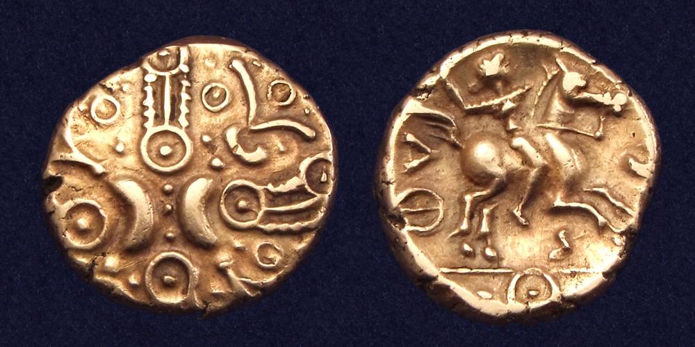
The Dobunni are among the tribes of southern Britain that struck their own coins before the Roman conquest. The material is unusually rich, which is why we know more names for the Dobunni than for many a larger group. The gold coins, called staters (a stater is the Celtic gold coin that follows Greek models), carry letters in the Latin alphabet. The series named in the literature runs: Corio, Bodvoc, Comux, Catti, Inam, Anted and Eisv; a dealer's catalogue spells the last name “Eisu”, and the name Inam appears in another description in a garbled form. We follow the reading on the coins as far as it is attested in the catalogues we saw.
For two of these names we have descriptions of the coins themselves. On the stater of Corio, CORIO stands above a horse on the reverse, and the obverse shows a tree-like sign with three branches and a pellet at the foot; according to the Van Arsdell catalogue it is the heaviest piece of the dynastic series. On Bodvoc's coin, by contrast, the name BODVOC fills the field of the obverse, and the reverse shows a horse, an eight-spoked wheel and a crescent. Anted bears ANTED on the reverse above a three-tailed horse with a wheel beneath; behind it often comes an addition such as RIC, RIGV or RICOV, which the dealer's catalogue reads as an abbreviation of a Celtic word for “king”. The catalogue lists the group under the name “Antedrig”. Whether the word really means a royal title is a reading, not a certainty; the other coins carry no such addition. The horse on the reverse is, by the way, widespread on British coins. On the horse in the Celtic imagination see our article on sacred horses; that the Dobunnic horses meant anything special is not something the sources give.
The sequence is harder. The Van Arsdell catalogue places Corio at about 30 to 15 BC and Bodvoc at 15 to 10 BC. An auction house that in 2024 offered a hoard of six Bodvoc staters found at Standlake in Oxfordshire in 2023 dates Corio instead to about 20 BC to AD 5 and Bodvoc to about 5 BC to AD 10, each with question marks, and Anted to about AD 20 to 35 and Eisv to about AD 30 to 43. The dates differ by decades. They are estimates from stylistic comparison and find circumstances; anyone who names a regnal year goes beyond what is known.
Some things do follow from the coins. Of Bodvoc, according to the hoard description, 77 gold staters from 37 reverse dies are known, lying on the English side of the Severn and reaching east as far as about Wallingford, densest in Oxfordshire and Gloucestershire. The authors of the hoard report even consider that Bodvoc may not have been a local ruler, since his coins differ strongly from the other Dobunnic issues. Overall, the coinage suggests that the rulers divided their territory into a northern and a southern part, at times under a common lord. That is a result of distribution maps and not a word of the Romans. And that someone had his name put on a coin does not yet make him a king in the Roman or Celtic sense; an overview of the Dobunnic rulers' lists points out explicitly that it is uncertain whether all (or any) of the coin issuers ruled the whole tribe.
About six kilometres north of Cirencester lies the village of Bagendon, and around the village run banks and ditches known as the Bagendon Dykes. Elsie Clifford dug there from 1954 to 1956 and published her results in 1961 under the title Bagendon: A Belgic Oppidum. An oppidum is a large, usually fortified Celtic settlement of the last two centuries before Christ that served as a centre of trade, craft and power at once. The word “Belgic” in the book's title comes from the research language of the time and goes back to older assumptions about immigrants from Gaul; we have not examined it further and do not adopt it.
The newer study is by Tom Moore and colleagues, who worked at the site between 1979 and 2017; the result appeared in 2020 as A Biography of Power. From the reviews and a summary of the text the following picture emerges. The beginnings lie in the Middle Iron Age: small “banjo-shaped” enclosures, of a kind also known from Gussage Cow Down in Dorset, formed the core, and the first ramparts belong to that early phase. The weight lies in the Late Iron Age, with a peak around the middle of the first century AD; most activity falls in the years from about 40 to 60, though it may have begun around 20. The earthworks cover some 200 hectares, of which about 150 hectares have so far been surveyed geophysically. The densely used core area in the valley measures about 16 hectares. Moore describes Bagendon as “polyfocal”, meaning that high-status enclosures and craft areas lay apart from one another instead of in a single town. Clifford's excavation of 1954 to 1956 found signs of coin production and other trades.
Individual finds are telling: a quernstone of conglomerate rock (“pudding stone”) that comes from Hertfordshire, and coins of Tasciovanus, a ruler of the Catuvellauni. Moore sees in them close links with Verulamium, the Catuvellaunian centre near St Albans. That fits Dio's statement that a part of the Dobunni was ruled by the Catuvellauni; it is no proof, since exchange is possible without rule. That the conquest barely harmed the site seems established: on Moore's account it flourished immediately afterwards. He interprets the Roman fort on the edge of later Cirencester, called “Leaholme” in the literature and placed by Moore probably in the AD 50s, as a possible sign of Roman backing for the local elite, perhaps in the form of a client kingship. Around AD 60 parts of Bagendon and the neighbouring Duntisbourne enclosures were abandoned as development shifted to Cirencester. Villas were later built within the area of the old complex. Whether Corinium replaced Bagendon because that was wanted politically or simply because the site was better, Moore expressly leaves open.
From this account it follows that Bagendon is a centre of the Dobunni, that is Moore's interpretation, but the statement “the capital of the Dobunni” is modern wording. Other sites, such as Salmonsbury, are equally large and in part became known earlier.
Salmonsbury Camp lies east of Bourton-on-the-Water on a gravel terrace between the rivers Dikler and Windrush. The enclosure is rectangular, about 23 hectares in size and surrounded by two ramparts with outer ditches; on the north, east and south sides the earthworks survive up to two metres high. A drawing of 1840 and observations from 1881 show that the whole outline could still be traced then. G. C. Dunning dug here from 1931 to 1934. He found two Iron Age occupation phases: an older one before the defences, which he placed in the later first century BC, and a younger one that fits the building of the ramparts, in the first half of the first century AD. In both phases there were roundhouses, rubbish pits, pottery and metalwork, among them a hoard of 147 so-called currency bars that had been discovered in 1860. Currency bars are standardised iron bars that evidently served as a means of exchange and payment. According to Historic England's description, settlement lasted into the fourth century AD, and in Roman times the camp possibly served as a market place beside the small Roman town at Bourton Bridge. A charter of King Offa of Mercia from 779 calls the place “Sulmonnes Burg”. The official description does not mention the Dobunni; the attribution comes from the location, not from a find that says “Dobunni”.
The White Horse of Uffington often appears in the same context, a hill figure on the chalk slopes of Whitehorse Hill in present-day Oxfordshire (formerly Berkshire). It is considered a tribal sign, and because the horse on coins of the Dobunni and the Atrebates shows similar forms, a connection was drawn as early as the seventeenth century. That does not stand up to scrutiny. A dating by optically stimulated luminescence, carried out by the Oxford Archaeological Unit after an excavation in 1990, placed the silt deposits beneath the figure in the period between 1380 and 550 BC. That would be Late Bronze Age to Early Iron Age, clearly before the coins and long before the Dobunni as Dio and Ptolemy know them. Stuart Piggott's dating to about 100 BC from 1931 was overtaken by the measurement. The figure cannot therefore be booked as a Dobunnic sign; which community laid it out, we do not know. For the Westbury horse in Wiltshire we found no evidence of an attribution to the Dobunni.
In AD 43 Aulus Plautius landed in Britain with an army on the orders of the emperor Claudius. Dio, writing more than 150 years later, tells the course of events in Book 60 of his Roman History, drawing on older literature that has not survived. After the landing and the first fights comes the passage that mentions the tribe. We give it in sense, in our own English rendering adapted from Cary's translation; we could not check the Greek text:
Plautius defeated first Caratacus and then Togodumnus, the sons of the late Cynobellinus. The Britons were divided into groups under various kings. After these had fled, he won over by capitulation a part of the Bodunni, who were ruled by a tribe of the Catuellani, left a garrison there, and advanced to a river.Cassius Dio, Roman History 60, 20, 1–2; in sense, after the translation by E. Cary (Loeb, 1914), own rendering, Greek text not checked
The sentence contains four statements. First, the Bodunni, probably the Dobunni, were not opponents in open battle: only a part of them gave in, “by capitulation”. Second, a tribe named Catuvellauni is said to have ruled them, and Dio gives this as the state of affairs at the time of the campaign. Third, Plautius left a garrison; where, Dio does not say. Fourth, Dio says nothing about Bodvoc, Eisv or any other name from the coins. The view that one of them negotiated with Plautius in 43 is a conjecture, and the coin dates rather suggest that Bodvoc ruled earlier.
There is a side note that concerns the Rhine. Later in the narrative (60, 20) Dio writes, in Cary's translation “Germans”, that Germans swam across a river and wounded the Britons' chariot horses. Whether this means Batavian auxiliaries, as research often assumes, Dio does not say; it is an interpretation. The Batavi at the mouth of the Rhine supplied cavalry to the Roman army; we have not checked the link to this passage in any primary source. Dio places the scene at the river, after the capitulation of the Bodunni, and it remains uncertain whether the two events were connected in space.
Anyone reading about the conquest of Britain expects Tacitus, and indeed Book 12 of his Annals has a passage that touches the Dobunni's area. It is nonetheless no testimony about them. Publius Ostorius Scapula took over the command in AD 47, and in Tacitus (Annals 12, 31) the account opens with the sentence “At in Britannia P. Ostorium pro praetore turbidae res excepere”, roughly: in Britain the governor Ostorius was met by unsettled conditions. The enemy had broken into the land of allies. Ostorius had cohorts advance quickly, disarmed suspect groups and prepared a line between two rivers, one of which is the Sabrina, the Severn. The name of the other is corrupt in the transmission; some editors read it as the Trent, and some scholars connect the line with the Fosse Way, the road linking Trent and Severn. That is a textual emendation and an inference, not a certainty. The Iceni resisted the disarmament, Ostorius stormed their fortified enclosure, then it went against the Silures, and in 51 he defeated Caratacus, who fled to the Brigantes and was handed over. Of the Dobunni there is nothing in all this. That the Fosse Way runs through Cirencester brings their territory near the frontier line but does not make them actors in Tacitus's text.
For our question a sober conclusion follows: the silence of the sources does not mean the Dobunni did nothing, only that we do not know their actions from texts. Everything we say about their role in the years after 43 comes from finds and from Dio.
From the early phase of the Roman occupation two tombstones survive in Cirencester that give unusually much for our region. Both were found in the nineteenth century in the district of Watermoor, close together, and now stand in the Corinium Museum. Both show a mounted soldier above a fallen enemy.
One stone (Roman Inscriptions of Britain, RIB 109) names Sextus Valerius Genialis, a trooper of the Cavalry Regiment of Thracians, “civis Frisiavus”, a citizen of the Frisiavones. He died aged 40 after 20 years of service; his heir had the monument set up. According to the note in the inscription corpus the Frisiavones are a tribe in Gallia Belgica and are not to be confused with the Frisians. We have a separate article on the Frisiavones. The Corinium Museum assumes that Genialis was recruited in Lower Germany, where the unit is thought to have been until 43, and that he died around AD 60; the inscription corpus dates the stone on style to about 45 to 75. The Thracians were, according to the museum, the first garrison of the fort at Cirencester.
The other stone (RIB 108) belongs to Dannicus, a trooper of the Ala Indiana, from the troop of Albanus, 16 years of service, “cives Raur(icus)”, thus a citizen of the Raurici, whose chief town Augusta Raurica lay at Augst in Switzerland. The heirs Fulvius Natalis and Flavius Bitucus had the stone erected in accordance with his will. This one too is dated on style between 45 and 75. The Ala Indiana was, according to the museum, the second garrison. The unit's name is traced in research to Julius Indus, a Treveran who fought on the Roman side in AD 21 in the revolt of Florus and Sacrovir. Tacitus tells of it in the Annals (3, 42) and calls Indus “of the same tribe” as Florus, that is, a Treveran; that the cavalry is named after him, however, does not stand there, it is an inference. On the Treveri on the Moselle we have the article on the Treveri, and for the larger frame the text Germanic Peoples in the Rhineland.
For the Aachen region and for Alsdorf no source known to us says anything about the Dobunni, and we do not invent a connection. What the stones show is something more general: the Roman army the Dobunni experienced consisted in part of men from the Lower Rhine to the Upper Rhine near Basel, and some of them stayed to the end of their lives where they had built their camps.
According to the museum the fort at Cirencester guarded the crossing of the river Churn and a road junction. The museum dates its construction “probably 43 or 44”; Moore places the fort of Leaholme in the 50s, and another account says about 60. Three figures for one and the same site show how uncertain the date is. According to the museum the troops were withdrawn around 70. Afterwards Corinium became the chief town of the civitas, the Roman-organised administrative unit of a tribe. By one account that happened around the middle of the 70s, by another the tribal town was set up only in 96 to 98 under Nerva. For Corinium the literature names a forum and basilica larger than any other in Britain except that of London, second-century walls that enclosed the second-largest urban area of the province, an amphitheatre called the “Bull Ring”, and probably local mosaic workshops whose Orpheus pictures are well known. The Fosse Way, Akeman Street and Ermin Way met here. The size figures rest on the usual accounts; we have not checked them against excavation reports.
At the same time another centre arose at Gloucester, Roman Glevum. According to the accounts we could consult, the place received the rank of colony under the emperor Nerva in AD 97, a settlement for veterans with Roman citizenship, with the name Colonia Nervia Glevensium. For the place's earlier history as a military base the accounts differ on date and legion; we therefore do not name them. The organised tribal town of Corinium and the colony of Glevum exist side by side in the land the Dobunni once inhabited. That wealth and power moved into these towns fits Moore's finding that Bagendon lost importance in the course of the first century.
Around 296 Diocletian divided Britain into four provinces. Cirencester probably belonged to Britannia Prima and was perhaps its capital; that is not certain. The best evidence is a column base found in Cirencester in 1891 (RIB 103). It says that a Lucius Septimius, governor of Britannia Prima and “civis Remus”, a citizen of the Remi, restored a statue and a Jupiter column that had been erected under the “ancient religion”. The editors, following the 1995 addendum, date the inscription to 296 or 312 and reject the earlier dating under Julian. Here again someone from Gaul appears: the Remi lived around Reims.
Whether the tribal name Dobunni was still alive in this period, the sources do not say. One account gives about 409 as the end of the tribal community, without evidence; we do not adopt the figure. After Rome's withdrawal the area is said to have kept its independence until the battle of Dyrham in 577, which some regard as doubtful; the Saxons are then said to have advanced to the Severn. Later the region belonged to the sub-kingdom of the Hwicce under Mercian influence. A continuity from the Roman tribal area to that kingdom is claimed but disputed, and the derivation of the name via the word “cup”, which is supposed to link the two names, has been sharply criticised by several archaeologists. More than this cannot be said on the basis of our sources.
Certain are the Dio passage in its translation, Ptolemy's entry, the coin legends, the earthworks of Bagendon and Salmonsbury, the two tombstones and the governor's inscription. Plausible is that Dio's “Bodunni” are the Dobunni, that a part of the tribe had earlier been tied to the Catuvellauni, and that the Romans kept a garrison in Cirencester early. Interpretation remains the origin of the name, the extent of the coin rulers' domains, Bagendon's role as a political centre, the building and withdrawal dates of the forts, the role of client kings and the connection with the Hwicce. Legend is the attribution of the Uffington horse. The Dobunni are thus a tribe we know mainly through things one can hold in the hand: coins, earth ramparts, tombstones. Their language they left only in names, and their gods and customs are hardly tangible for the time before Rome.
In our family workshop in Alsdorf we make laser-engraved slate plaques with Norse-Germanic and Celtic motifs. For the Dobunni there is no handed-down sign we could document as their own, and so we invent none; the horse on their coins is a coin image and not an attested tribal emblem. For the overview of the Celtic world see Celts; to their neighbours in the east, the Catuvellauni, and in the west, the Silures, we have devoted articles of their own.
The Silures · The Catuvellauni · The Iceni · The Treveri · The Ordovices.
All History & Finds articles →
Donar's Oak (also called Thor's Oak or Jove's Oak) was a huge sacred tree in northern Hesse that the Anglo-Saxon …
Read more →Dorestad was one of the largest trading places of the Frankish empire in the 8th and early 9th centuries: a port of …
Read more →Not a single sentence in their own language survives from the Drougoubitai. What we know about them comes from the …
Read more →