Menzlin on the river Peene, a few kilometres west of Anklam in north-eastern Germany, was a trading and craft site from the late 8th into the 10th century where Slavic locals and Scandinavians lived side by side. It is famous for something found nowhere else on the southern Baltic coast: graves laid out as stone ships in the Scandinavian manner, excavated by Ulrich Schoknecht between 1965 and 1969. This guide sorts out what was actually found, what is only guessed, and how Menzlin compares with Ralswiek, Wolin and Hedeby.
Picture a low sandy rise with wet meadows on either side and the Peene sliding slowly towards the lagoon below. No rampart, no stone wall, no royal hall. Yet some 1,200 years ago boats beached here whose people wore brooches made in Sweden, knew belt fittings from Ireland and counted in silver that had once left the mints of the Caliphate. If you drive down the concrete-slab track from the village of Menzlin today, you will see nothing of that at first. Only when you climb the steps up the wooded slope and spot the first lines of stones in the grass does it sink in: someone buried their dead here the way people did in Uppland or on Gotland, in the middle of Slavic country.
No saga mentions Menzlin, and no chronicler has a king die here. That is exactly why it rewards a closer look. What lay in the ground on the Peene says more about how people actually lived together around the Baltic than many a famous battle account.
The trading site lies about 1.5 kilometres south of the present village of Menzlin (municipality of Ziethen, district of Vorpommern-Greifswald) on the north bank of the Peene. The field is called Peeneberg; the cemetery to its east is known as the "Altes Lager", the "Old Camp". The name has nothing to do with Vikings. It most likely recalls the camp Brandenburg troops pitched here during the siege of Anklam in 1676. What the people of the 9th century called their settlement is unknown. Even "Menzlin" is a Slavic place name first recorded in 1231 as "Mancelin", in a charter of the Pomeranian duke Wartislaw III, centuries after the trading site had gone.
Why here? Along its lower course the Peene is flanked by broad fens. Anyone travelling east or west had to cross the valley somewhere, and at Menzlin dry sand reaches close to the river. The rise was protected on three sides by wetland, overlooked the valley and sat on a navigable river that leads through the Peenestrom and the Szczecin Lagoon to the open Baltic. Water route and land route met here, and that is precisely the kind of junction merchants looked for across the whole Viking-Age trading world.
In the high Middle Ages the long-distance road from the Elbe to Szczecin, often called the "Via Regia" today, ran through this area. Around 1075 Adam of Bremen describes an overland route from Hamburg to the town of Jumne at the mouth of the Oder that took seven days. Whether that road already crossed the Peene at Menzlin in the 9th century is a reasonable assumption, but not a proven one.
People had long known there was something in the ground on the Peeneberg. In 1905 sherds from a "prehistoric grave near Menzlin" reached the local museum in Anklam. From 1927 amateur researchers collected pottery, glass beads, raw amber and iron fragments on the ridge. In 1938 the Greifswald archaeologist H.-G. Hackbarth opened a barrow in which later burials with iron rivets lay above a Bronze Age grave, a clue nobody quite knew what to do with at the time.
The breakthrough came in 1965 to 1969. On behalf of the Museum of Prehistory and Early History in Schwerin, Ulrich Schoknecht (1930–2023) excavated parts of the settlement and the cemetery, helped by sixth-formers from the Anklam secondary school, volunteer heritage wardens and local people. He published the results in 1977 as Menzlin. Ein frühgeschichtlicher Handelsplatz an der Peene, which remains the basis for nearly everything written about the site.
More work followed. In 1974 dredging in the Peene brought up an iron sword, a spearhead, a bridle bit and pottery, and in 1990 archaeologists from Schwerin uncovered the stone road down to the river. Volunteer wardens still record whatever the plough turns up.
Here is the first tricky point, and we would rather be upfront about it. Many accounts say the settlement covered about 18 hectares in the 9th century, with a cemetery of roughly three hectares. Other summaries give only some 9.7 hectares (about 590 by 165 metres) for the settlement proper and 2.7 hectares for the cemetery. The difference probably depends on whether the cemetery, the margins and the scatter of finds along the bank are included. What is certain is that only a small part was excavated. Nobody knows how many houses there were, only how many features were investigated: four houses, a storehouse and three workshop buildings are mentioned.
For scale: Hedeby enclosed some 24 hectares within its semicircular rampart and probably had over a thousand inhabitants in the 10th century. Menzlin was no second Hedeby, but no hamlet either. Think of a medium-sized transshipment point, one of several along the southern Baltic coast.
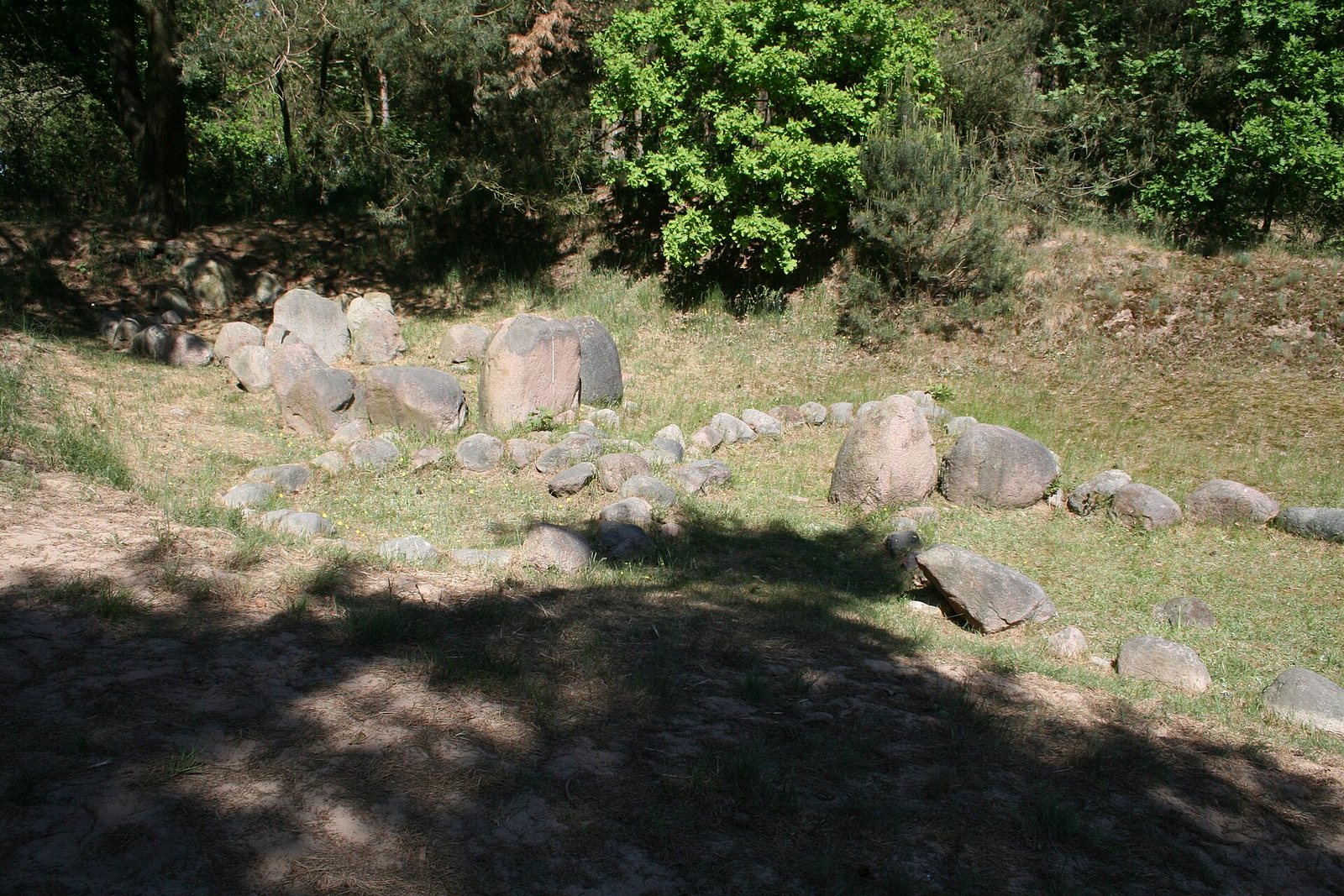
The heart of Menzlin is its cemetery. On a small inland dune at the eastern end of the ridge, Schoknecht found eight ship-shaped stone settings. A ship setting is a line of stones, set upright or laid flat, that traces the outline of a vessel: pointed at stem and stern, wider amidships. The Menzlin examples are small, roughly 2.30 to 7.50 metres long and 2.50 to 4.60 metres wide. Alongside them were eleven (some sources say twelve) stone circles, 33 cremation graves and an ustrina, a place where the dead were burned.
In Scandinavia this kind of grave is common. The best-known cemetery is Lindholm Høje near Aalborg, with around 700 graves including many ship settings; Gotland has hundreds, and Ale's Stones in Scania stretch 67 metres. You will find more in our article on stone ships. South of the Baltic, though, Menzlin is by current knowledge the only site where ship settings were clearly laid out on the Scandinavian pattern. That is what makes this small wood on the Peene so important.
What did the ship mean? No one who buried their dead this way left us an explanation. A voyage to the otherworld is the obvious thought, and real boat burials point the same way, but that is a modern reading. The ship could just as well have signalled status, origin or membership of a seafaring community. One detail stands out: some graves held iron double rivets and nails of the kind used in clinker-built boats. Whether these are remains of burnt boat timbers given to the dead or a hint of a boatyard in the settlement is read in different ways.
"Wits must he have who wanders wide, but all is easy at home."Hávamál 5, trans. Henry Adams Bellows, 1923 (public domain)
Now for the detail that makes Menzlin special. The grave goods point to women: oval brooches, the paired bronze brooches Scandinavian women used to fasten their strap dresses, plus beads and jewellery. No men's graves with weapons have been recognised at the Altes Lager so far. Whether there were none, whether they were simply furnished, or whether they lie in the unexcavated part of the cemetery remains open.
And the ashes of these women were placed in urns that are mostly Slavic pottery of the Feldberg group, a finely made and often decorated ware of the 8th and 9th centuries named after a hillfort near Feldberg in Mecklenburg. Scandinavian dress, Scandinavian burial rite, Slavic pot. You can hardly pack more mixing into one grave.
How to read this depends on where you stand. Some accounts conclude that Scandinavian women lived here with their households and used pots from the local market. Others speak of Scandinavian men marrying local women, which fits poorly with graves furnished with Scandinavian women's dress. Tourist texts mention "anthropologically identified" Scandinavian women; how far that holds for cremated bone is questionable, and we know of no DNA or isotope studies for Menzlin. The honest answer: the graves show people who presented themselves as Scandinavian in death, within a community that used Slavic tableware as a matter of course.
Schoknecht's excavations and the surface finds add up to a range typical of a trading site, with a few outliers that point far beyond the region.
From Scandinavia: oval brooches, including a bronze one with shell inlay found among surface finds in 1970. An iron ring with two Thor's hammer pendants: such "Thor's hammer rings" are known above all from the Lake Mälaren region of central Sweden and from Åland, which fits the widely held view that Menzlin's Scandinavians came from what is now Sweden rather than Denmark. When surface finds were re-catalogued in 2015, archaeologists found the matching piece to an already known fragment of a Gotlandic-type fire-steel plate decorated with a human figure in the Borre style. So Gotland is in the picture too.
From further afield: a belt fitting described as Irish-Scottish or Anglo-Irish, and jewellery from the eastern Baltic. Beads of amethyst, rock crystal, carnelian and glass, materials that do not occur in Western Pomerania. Carnelian, for instance, reached the north from India or Iran via the rivers of Eastern Europe, as we describe in our piece on carnelian beads. Melted glass beads turned up in the cremation graves.
From local workshops: evidence for antler comb-making, amber jewellery, antler spindle whorls, bone needles, iron knives and arrowheads, plus traces of weaving and smithing. Raw amber was among the earliest surface finds. How comb makers worked is explained in our article on comb makers and bone carvers, and for the raw material itself see our piece on amber.
Then there is a recent find that made the news in 2023: a decorated bronze pin, 7.3 centimetres long, picked up on the site by a volunteer heritage warden in late 2022. It shows a man's head with a bird perched on it; originally there were probably two. The state heritage office dates it to the 8th, perhaps the 7th century and points to parallels in Denmark and Sweden. Odin with his ravens? Possibly. The archaeologist in charge stressed that the question stays open: another god, a hero or a warrior are all candidates, and similar images are known from the Slavic world too. That, in our view, is exactly how such objects should be discussed.
A trading place without money? Of course not. But in the 9th- and 10th-century Baltic, money mostly meant silver by weight. Coins and ornaments were chopped up, the pieces weighed on small folding scales, and payment was whatever the scales showed. More on this in our article on hacksilver.
For Menzlin itself, weights and a few coins have been reported among the surface finds; the reports available to us do not say which coins. We could not securely confirm folding scales from the site in the sources we reached, so we do not claim them.
Close by, however, is a find that makes the region's silver economy tangible: the Anklam silver hoard. In August 2010 archaeologists from the state heritage office and the University of Greifswald, helped by around 15 volunteers, recovered 82 coins and coin fragments from a field near Menzlin, together with remains of silver ingots, a massive arm ring made in the Volga region and a fragment of an arm ring of the so-called Permian type. The coins are Arabic and Persian issues, the oldest from the reign of the Sasanian king Khosrow II (590–628). Together the coins weigh only about 200 grams; the Greifswald historian Fred Ruchhöft reckoned the owner could have bought roughly four oxen with them. The hoard lay at the edge of a Slavic settlement, not on the trading site itself, but it shows that dirhams, the silver coins of the Islamic world, travelled the Eastern European river routes all the way to the Peene. For hoards on a far larger scale, see our article on the great Viking silver hoards.
One of the most impressive features lies not on the ridge but down in the valley. A made road led from the settlement to the Peene, paved with stones and reinforced with oak planks, more than 100 metres long and about 3.50 metres wide according to the literature. Archaeologists have also identified a wooden bridge across the river and the road's continuation on the south bank towards Görke. Remains of the bridge were noted in the 1960s; the stone road was excavated in 1990.
According to the literature, dendrochronology, dating by the tree rings of the timbers, confirms the link with the trading site. One regional account gives a construction date of around 770 for the road. We could not check that exact date in a specialist publication, so treat it as a rough guide rather than a firm year. The road is regarded as one of the oldest paved roads in Mecklenburg-Western Pomerania.
And the harbour? It is assumed to have been at the end of the road on the riverbank. In 1969 large pointed oak planks came to light during dyke building and may belong to a bank revetment. A harbour in the sense of an excavated landing stage, though, is not proven. For trade, flat boats pulled up onto the shore were enough anyway.
Without the Slavs there would have been no Menzlin. The settlement pottery is mostly early Slavic, the site lay in densely settled Slavic land, and the Scandinavians needed partners who brought grain, livestock, honey, wax, furs and probably people, as slaves, to market. The traders did not arrive in empty country but in a land with its own strongholds, tribal groupings and rulers.
Which group exactly held the lower Peene is harder to say than it often sounds. In the late 8th and 9th centuries Frankish sources name the Veleti (Wilzen) in this area, against whom Charlemagne campaigned in 789. From the late 10th century the Lutici federation appears, which included the Tollensians and the Circipanians, among others. Standard reference works assign Menzlin to the Lutician Tollensians; since the site lies on the north bank of the Peene, a link to the Circipanians is also conceivable. Pottery alone cannot reveal a tribal border. Only in the 12th century did the land on the lower Peene come under the dukes of the Pomeranians, hence Wartislaw III's charter of 1231.
One point matters to us: the Slavic side was no mere backdrop for "the Vikings". Feldberg pottery is among the finest work northern potters produced at the time. Slavic strongholds and markets organised exchange in the hinterland, and no foreign trader could have stayed on the Peene without the consent of local rulers. Scandinavian women buried in Slavic vessels speak of neighbourliness rather than conquest.
Menzlin was one link in a chain of trading places along the southern Baltic coast, each with its own character.
Ralswiek on Rügen, on the Großer Jasmunder Bodden, was excavated from 1972 by Joachim Herrmann. Four boat wrecks and a large barrow cemetery were found there, and in 1973 a silver hoard with around 2,200 Arabic coins. Ralswiek flourished slightly later than Menzlin, mainly in the 9th and 10th centuries, and like Menzlin it was a Slavic-Scandinavian site. It has no Scandinavian-style ship settings.
Wolin at the mouth of the Oder grew into the largest trading town in the region, called Jumne or Julin in the sources and later linked with the legendary Jomsborg of the Jomsvikings. Wolin was clearly a Slavic town with Scandinavian guests, not the other way round.
Hedeby on the Schlei, finally, was a Danish-controlled long-distance trading town with its own rampart, its own coinage and royal power behind it. When the Danish king Godfred destroyed the Obodrite market of Reric in 808 and moved its merchants to Hedeby, he showed how much trading places depended on political power.
Menzlin fits this picture as an early, smaller site whose heyday falls mainly in the 9th century. Its distinction is not size but the clarity with which a Scandinavian burial custom becomes visible on Slavic soil. For more sites, see our overview of Viking traces in Germany.
Most datable finds belong to the early and middle 9th century, with individual pieces reaching into the 10th. After that the trail goes cold, and we do not know why. Shifting trade routes, the rise of Wolin, political upheaval among the Slavic groups or simply a fire after which nobody rebuilt are all conceivable.
The regional historian Lutz Mohr has suggested that the Jomsvikings destroyed Menzlin around the year 1000. There is no archaeological evidence for this, and we know the Jomsvikings mainly from Icelandic sagas of the 13th century. We mention the idea because you will meet it in local literature, but it is a guess, not a finding. The same goes for attempts to identify Menzlin with Vineta or Jomsborg.
Later, Anklam took over as the trading town on the lower Peene. The village of Menzlin only appears in records from the 13th century and shares nothing with the early medieval site except its location.
The Altes Lager is protected today as a natural monument and is also a registered archaeological site. From the village of Menzlin you follow a signposted track (signs read "Wikingergräber", "Altes Lager" or "Kanuverleih"), the last stretch on concrete slabs. You cannot drive up to the cemetery. A small car park has an information board on the site's history and finds, and there are further boards by the river at the canoe rest area. A flight of steps leads up onto the wooded ridge, from where several ship settings are visible. The number of visible settings and the state of the boards may change; our research reflects autumn 2026, and nothing beats seeing it for yourself.
The site is a nature experience too. Steppe plants such as the small pasque flower grow on the inland dune, and to the south lies the Menzlin polder, rewetted since 2000, with an observation tower for cranes and waterfowl. Of the settlement itself nothing is visible on the surface. Please take this seriously: digging or metal-detecting on a protected archaeological site is a criminal offence and destroys exactly the contexts archaeology needs to tell its stories. No excavations are currently planned. Schoknecht's finds are to be displayed in the future state archaeological museum in Rostock. For more places to visit, see our guide Experience the Vikings.
For us in the workshop in Alsdorf, Menzlin shows why we dislike simplifying motifs. A brooch from Sweden, a pot of Feldberg clay, a stone ship in Slavic sand: they belong together. Take the Viking Age seriously and the Slavs come with it.

Where exactly is Menzlin? Menzlin is part of the municipality of Ziethen near Anklam in Western Pomerania, north-eastern Germany. The trading site and the "Altes Lager" cemetery lie about 1.5 kilometres south of the village on the north bank of the Peene.
Were there Vikings at Menzlin? Yes. Scandinavian graves with oval brooches, ship settings and Thor's hammer rings show people with Scandinavian dress and burial customs. But the site lay in Slavic territory, most of the pottery is Slavic, and it was a shared place.
How old are the Menzlin ship settings? They belong to the trading site and are dated to the 9th century, with the site itself beginning in the late 8th century. Individual graves cannot be dated more precisely.
Can you visit the Viking graves at Menzlin? Yes, the cemetery is freely accessible. From the car park with its information board, a footpath with steps leads up the wooded ridge, where several stone ships can be seen.
Were Arabic coins found at Menzlin? Nearby, yes: the Anklam silver hoard (2010) contained 82 Arabic and Persian coins and fragments. Weights and a few coins have been reported from the trading site itself, but we cannot say reliably what kind.
What is the difference between Menzlin and Ralswiek? Both were Slavic-Scandinavian trading places. Menzlin is somewhat older and has the Scandinavian ship settings; Ralswiek on Rügen is known for its boat finds, a large barrow cemetery and a hoard of around 2,200 dirhams.
For courage. For remembrance. For legends that live on.
Ralswiek on Rügen · Reric · Wolin & Jomsborg · Hacksilver – silver as currency · Viking traces in Germany.
All History & Finds articles →
To a farmer from Uppland, „the great city" was as unimaginable as another planet. Constantinople had walls that fire …
Read more →Whoever won did not always keep the spoils. In the Roman Iron Age, Germanic victors sank the entire equipment of …
Read more →